Siskiyou Chapter Society of American Foresters
Medford, Oregon February 21, 2006 Meeting Presentation
Lessons from B&B, Biscuit, & Babyfoot
Lake:
Why Wilderness Doesn’t Work in the West
B&B Complex Fires:
Recreational & Aesthetic Values of Active Management
![]()
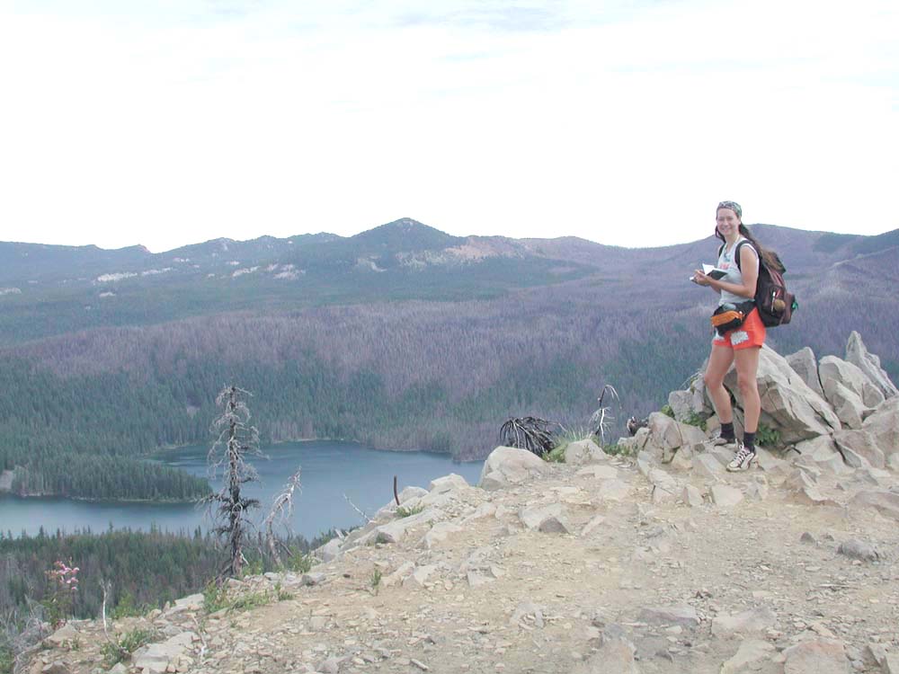
Nana Lapham takes GPS reading on peak of Marion Mountain, August 21, 2004. The northwest extent of the B&B Burn can be seen on the ridgeline behind Marion Lake, with spots and fingers reaching the lakeshore. Historical pastures, meadows, corrals, and campgrounds along the shoreline, Horse Pasture Creek, and Skyline Trail have filled in with conifer trees since WW II, forming a solid and flammable canopy that has reached into the old-growth overstory. (Photo: B. Zybach, ORWW).
Presentation by
President, NW Maps Co.
Program Manager, Oregon Websites and
Watersheds Project, Inc.
In the time since World War II, and even before, the grassland prairies, meadows, woodlands, berry patches, brakes, balds, and brush lands of the western US have been filling up with invasive migrations of pitchy, flammable conifer trees. In the Coast Range and lower to mid-elevations of western Oregon, the most common invasive conifer is Douglas-fir. In higher elevations it can be true fir (Abies, spp.), spruce, or mountain hemlock. In eastern Oregon, lodgepole pines invade old yellow pine and true fir stands, juniper spreads throughout the prairie grasslands, and true fir moves into mountain meadows and old-growth yellow pine understories.
These trees form solid blankets of pitchy fuels that stetch from dry shrubs and grasses to the dead or weakened tops of remaining old-growth trees. Under objectives found in most actively managed landscapes in the past, these trees would typically be burned, logged,or slashed before they became infested with disease or bugs, caught on fire, or otherwise became a threat to previously established trees, shrubs, forbs, browse, people, their property, and/or wildlife. In passively managed Wilderness areas and LSRs ("Late-Stage Successional Reserves" regulated to "preserve" old-growth and spotted owl habitat) that have recently been mandated into law, invasive conifers are allowed to spread and grow unchecked. When they subsequently burn up in lightning-caused or human-caused wildfires, as with the Silver Complex, B&B Complex, and Biscuit fires, they destroy vast amounts of the very trees and habitat the regulations were intended to protect! It seems unlikely these trees could ever have been logged so fast as they have been burned in wildfires the past 20 years; and in particular, during this century.
Dead trees are ugly to look at, despite recent attempts to paint other pictures of their appearance. They are blackened snags that have died and look bad for a long time to come. They are not a natural "spring time" in forestland as one "forest ecologist" recently testified to Congress and national television, they are dead. Winter, not spring. Dead. Big, tall, green, living trees look a lot better; everybody knows that. They look like healthy, vibrant, robust life -- even majestic, spiritual, or awesome under the right light or circumstances -- not like dirty, ugly reminders of death. And they're a lot less likely to fall over or burst into flames.
For campers and hikers, dead trees are not only ugly, they are sooty and dangerous. They fall across trails and tents in heavy winds and burn quickly with intense heat when they catch fire; or get charcoal all through your clothes and bedding when they don't. These trees have become heat- and air-dried, seasoned charcoal and firewood now; not the green, water-filled tubes and shrubs they used to be, before they were killed. Spectacular viewpoints, used for centuries and millenia, have become dominated or blocked by saplings, trees, and dead snags. Old meadows of wildflowers and ancient berry fields and nut orchards have been shaded out and burned to a crisp by invading conifer trees. Building a campfire is a danger -- or even not allowed at Marion Lake! -- because of all the dead wood caused by bugs and wildfire around childhood campgrounds. The snags need to be removed and the invasive trees significantly thinned to make this land safe and beautiful again. As Bill Hagenstein has said, this is an embarassment to his profession, Forestry, and it is not a fair condition to leave to our children and grandchildren: "they deserve better than this." This is not what our parents and grandparents gave us, and it should be repaired before it is passed on.
It is my opinion that the majority of these trees should be removed and used for some constructive purpose, whether currently in a Wilderness or an LSR. As invaders in the landscape (weeds), they could have served no historical or "natural" function, other than their recent aggressive and opportunistic response to the elimination of people, fire, and grazing in regulated, passively managed federal lands. At the least, publicly peer-reviewed, long-term, landscape-scale experiments should be established in all major federal forests to test the relative merits of passively managing resources as compared to more traditional methods used by people in the past; this recommendation also has merit for our national parks, wildlands, rangelands, wildlife preserves, and other large government landholdings with significant native plant populations.
|
Program Slides |
Titles, Summaries, & Related Links |
Presentation Files |
 |
B&B Complex Fires: Recreational Values of Active Management. The editorial above sums up the principal point of this part of my presentation. |
|
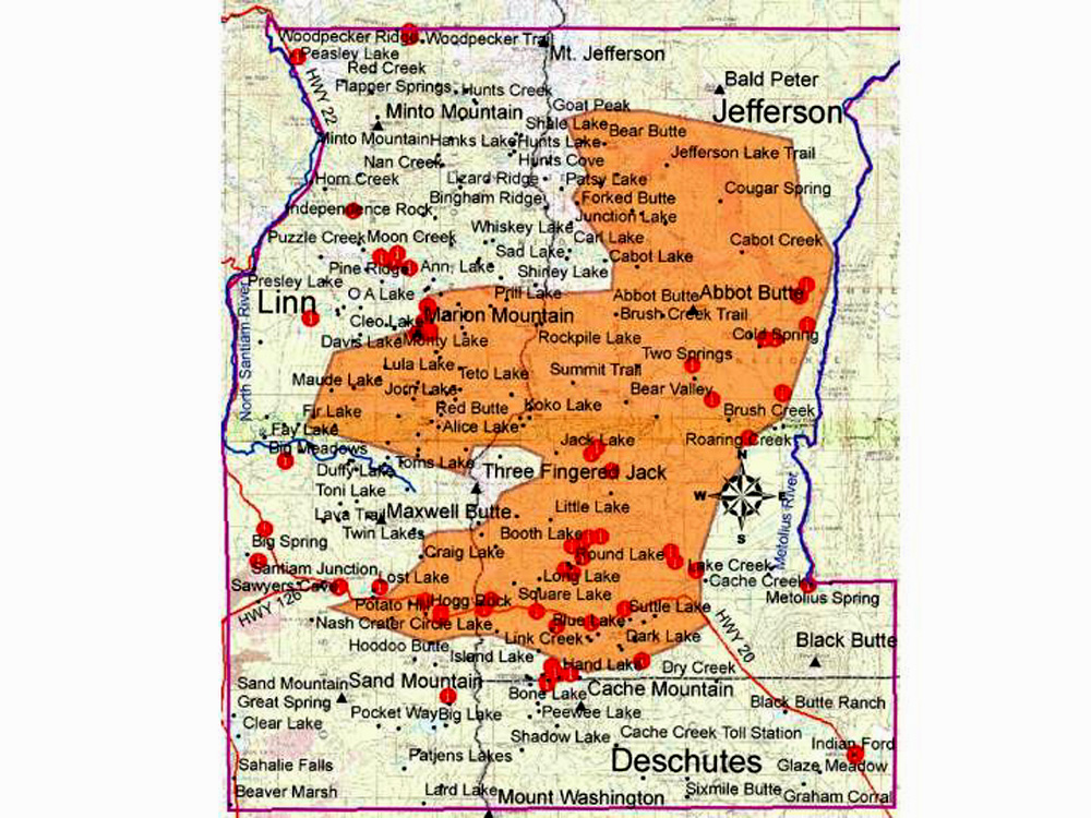 |
B&B Complex Repeat Photography Project. The recent advents of digital photography, cheap computer memory, accurate GPS receivers, GIS mapping, and Internet communications have added entirely new possibilities for documenting landscape change over time, particularly those that happen quickly, or with little warning. Earlier methods and technologies, such as aerial photographs, Osborne landscape mapping, and Repeat Photography, are all integrated into this approach. |
|
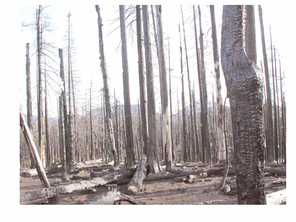 |
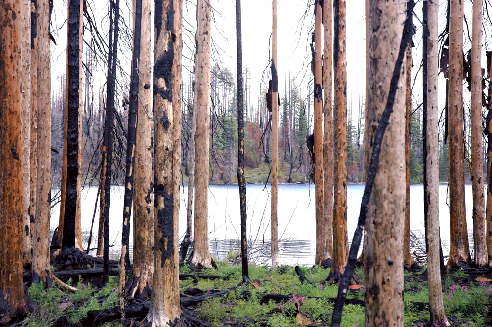
Skyline Trail (aka "Pacific Crest Trail" or "PCT"). Hiking trails are made hazardous, unsightly, and filthy dirty with the presence of thousands of dead and charred trees. This trail was famous for its sweeping vistas 100 years ago; now it is littered with dead, charred trees. |
|
 |
Marion Lake campground. Before this area was made into a Wilderness, families used to come to Marion Lake by foot and by horseback to camp, fish, and hunt for generations. Then the road was decomissioned, the gaurd station and outhouses removed, the corrals taken down, and the local meadows and grasslands began to fill with pitchy conifers. Many of the older trees along the lake's shoreline escaped this last fire, but they are surrounded by dead trees and filled with ladder fuels at this time. And no campfires allowed to reduce the local fuel loads and help protect the remaining older trees. |
|
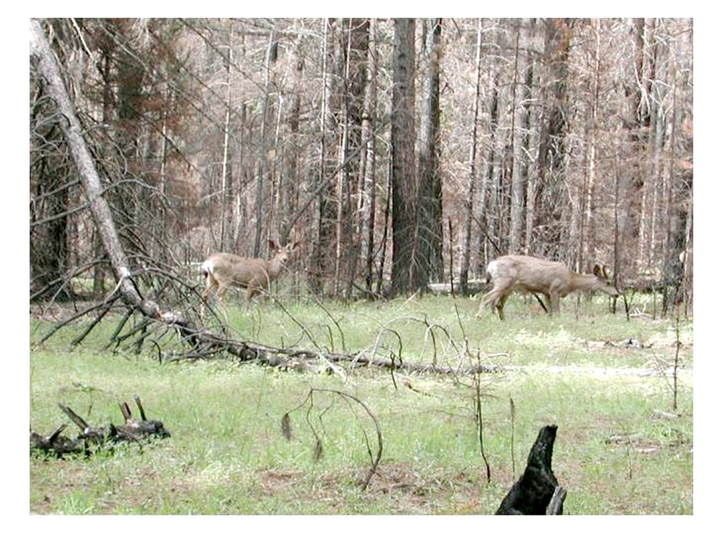 |
Wildlife Habitat. Deer, bird, bug, and wildflower populations often boom after a wildfire. The invasive conifers tend to develop a deep shaded forest floor covered with a thin blanket of acidic leaf ("needle") fall, excluding most other life forms. Regular fire is good for reptiles, bad for amphibians; good for flowers, bad for mushrooms; good for hawks, bad for owls; good for grass, bad for conifer seedlings and thickets. |
|
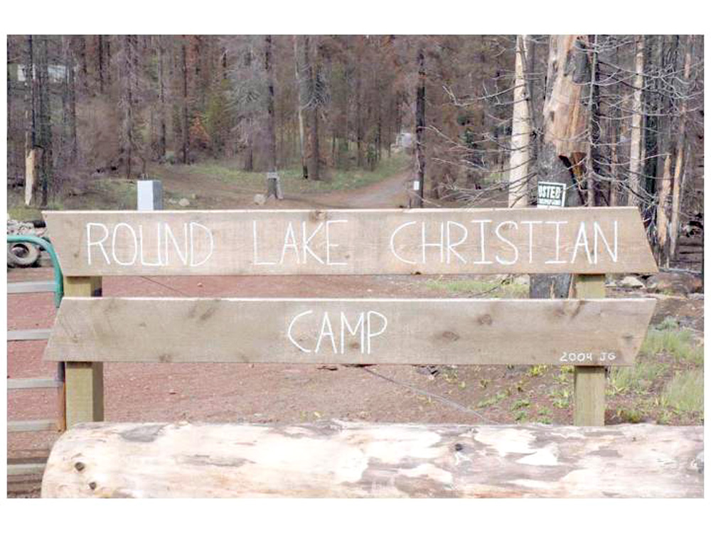 |
Round Lake Christian Camp. Long-term leases of USFS lands by Christian groups is fairly common in the B&B Burn area. A brand new wood building in this complex on the west shore of Round Lake was amazingly spared from fire damage. The same thing was true for Santiam Lodge, which is highly flammable and has been abandoned for several years. Despite saving the buildings, land use and aesthetics have been severely compromised. |
|
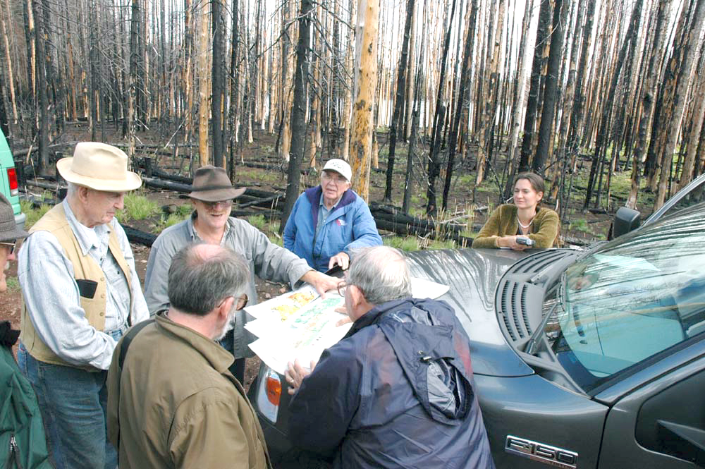 |
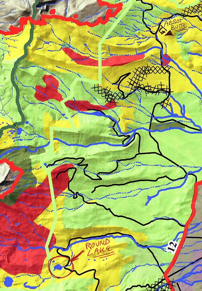
September 15, 2004 B&B Tour. This picture shows (clockwise from foreground) Kermit Cromack (OSU), Jim Peterson (Evergreen Magazine), Benjamin Stout (NCASI, ret.), Bill Hagenstein (IFA, ret.), Bob Zybach, Wayne Giesy (Hull-Oakes/ORWW), and Nana Lapham (OSU/ORWW) comparing the local landscape to USDA BAER "fire severity" maps issued shortly after the fire. We found very poor correlations at Round Lake and Abbot Butte, among other locations. Not included: videographer Mike McMurray, and photographer Brett Morrissette (PNW Research Station) | |
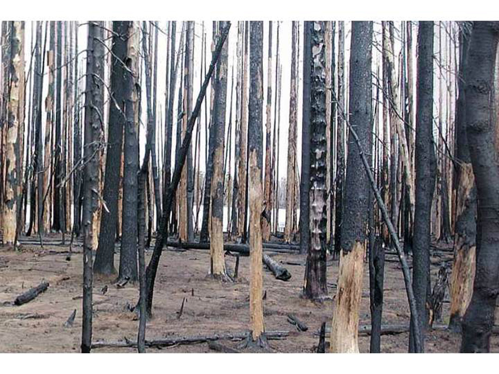 |
Round Lake QTVR Panoramas. Three locations near Round Lake, Oregon were chosen to establish GPS-referenced panoramic photo sequences. This original "West Shore" sequence was takenMay 15, 2004, as spring snows had just melted and vegetation had just begun to sprout for the first time in the new burn. |
|
 |
Round Lake West Shore: First Growing Season. This picture was taken four months after the previous picture, on Sept. 15, 2004. Ground that had been burned clean under an overstory of uniformly dead conifers had now, one growing season later, become covered with ferns and grasses and sprinkled with wildflowers. | |
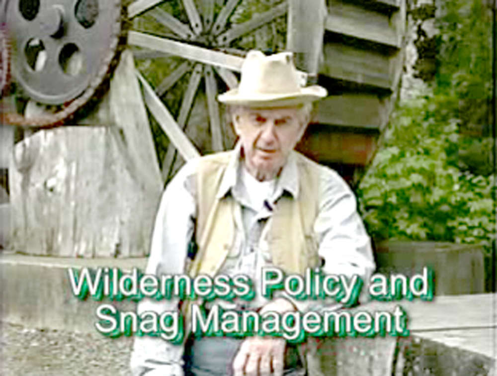 |
Bill Hagenstein: Wilderness Policy & Snag Management. Bill argues for the use of mechanical equipment, which is allowed under existing policy, to better manage wildfires within Wilderness boundaries. These remarks were made a few months before Mount Jefferson Wilderness (B&B Complex) caught fire, and events unfolded as predicted (23 mb., 2:10 min.). | |
|
|
Silver-Biscuit Complex Fires: Cultural Landscape & Wildfire Control Values of Active Management | NEXT |
© 2006 NW Maps Co.