Siskiyou Chapter Society of American Foresters
Medford, Oregon February 21, 2006 Meeting Presentation
Lessons
from B&B, Biscuit, & Babyfoot
Lake:
Why Wilderness Doesn’t Work in the West
Silver-Biscuit Complex Fires:
Cultural Values of Active Management
![]()
View east along the Doe Gap Trail from the Chetco Peak Fire Lookout Tower, June 25, 1937. Notice the size, distribution, and approximate age of conifer trees. Foreground is now Kalmiopsis Wilderness and backround (inclduing Josephine Mountain at about 70-degrees) is Siskiyou National Forest. Double-click on this image to get full 360-degree QTVR panorama, including zoom. To locate Chetco Peak in relation to the Kalmiopsis and other local 1930s fire lookout tower locations, see the Osborne Index Map.
Presentation by
President, NW Maps Co.
Program Manager, Oregon Websites and
Watersheds Project, Inc.
The Silver Complex Fires ocurred in 1987, and covered much of the Kalmiopsis Wilderness area. This was the first catastrophic-scale (100,000+ acre) fire in the history of the Klamath and Siskiyou Mountains in SW Oregon and NW California. In 2002, 15 years later, the Biscuit Complex Fires burned over the old Silver Complex Burn -- including the Kalmiopsis Wilderness -- and expanded the Fires' boundaries to 500,000 (1/2 million) acres. The Biscuit thus became the second catastrophic wildfire in the history of SW Oregon.
The Silver and Biscuit are named components of the same wildfire complex; sharing space and fuels, but separated by time. The history of trees killed by one catastrophic wildfire becoming principal fuels of subsequent catastrophic wildfires is typified by the formerly-famous "six-year jinx" Tillamook Fires of NW Oregon in 1933, 1939, 1945, and 1951. The 1933 wildfire, in turn, had been fueled in large part by the 1918 Cedar Flats Fire that had taken place 15 years earlier. These "Great" wildfires are among the largest in forest history, due in great part to the massive fuel build-ups that routinely take place in the conifer forests of the Douglas-fir Region. They are also among the largest forest fires in world history, and that is a key reason they are given so much public attention and produce so many economical salvage logging opportunities.
Migrating trees and catastrophic wildfires are testament to a forest region undergoing a fundamental cultural and biological change that is unprecedented since the melting of glaciers at the end of the last ice age, and the arrival of people and daily fire more than 10,000 years ago. As we make the transition from a region managed by fire to one managed by policy, it is critical not to lose important lessons from the past. Indian people set fires during fire season; not put them out. That way they avoided wildfire, their environment produced beautiful flowers and bountiful crops, and it was safe and wonderful land to behold. Native plants and animals adapted to the new, stable landscape patterns maintained by people, or went extinct. Some benefited, such as oak, camas, white-tail deer, and butterflies; and others were further marginalized or died out, such as elephants, camels, giant beavers, and Brewer spruce.
This presentation argues, perhaps counter-intuitively, that the more burning, pruning, and tilling we do following traditional local methods, the more old-growth and timber we are able to grow, maintain, and pass down to our descendents. Wilderness policy has resulted in one catastrophic wildfire after another. The Chetco didn't have this problem. If we follow their example, we won't either.
|
Program Slides |
Titles, Summaries, & Related Links |
Presentation Files |
 |
Silver-Biscuit Complex Fires: Cultural Values of Active Management |
|
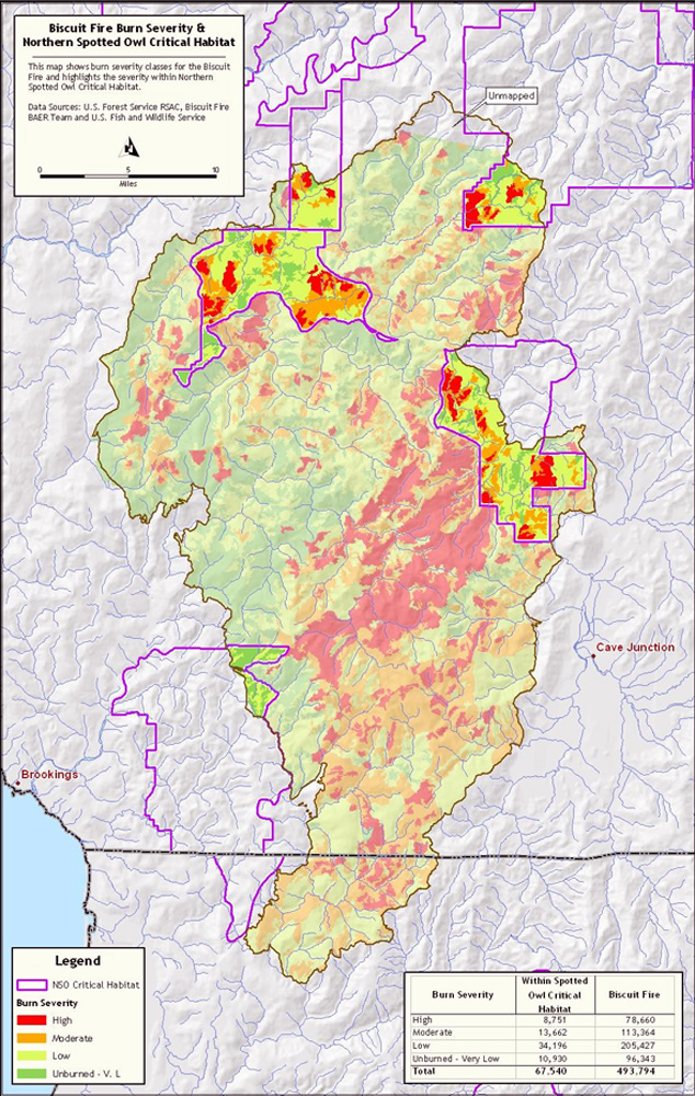 |
Spotted Owl Habitat & Biscuit Fire Severity Map. This map shows the amount of regulated owl habitat within the boundaries of the Biscuit Fire, and how that habitat may have functioned as fuel during the event. |
|
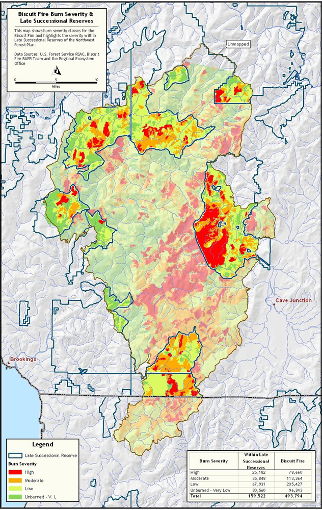 |
Old-Growth Forest ("LSR") Habitat & Biscuit Fire Severity Map. This map shows the amount of regulated old-growth tree area within the boundaries of the Biscuit Fire, and how those trees may have functioned as fuel during the event. |
|
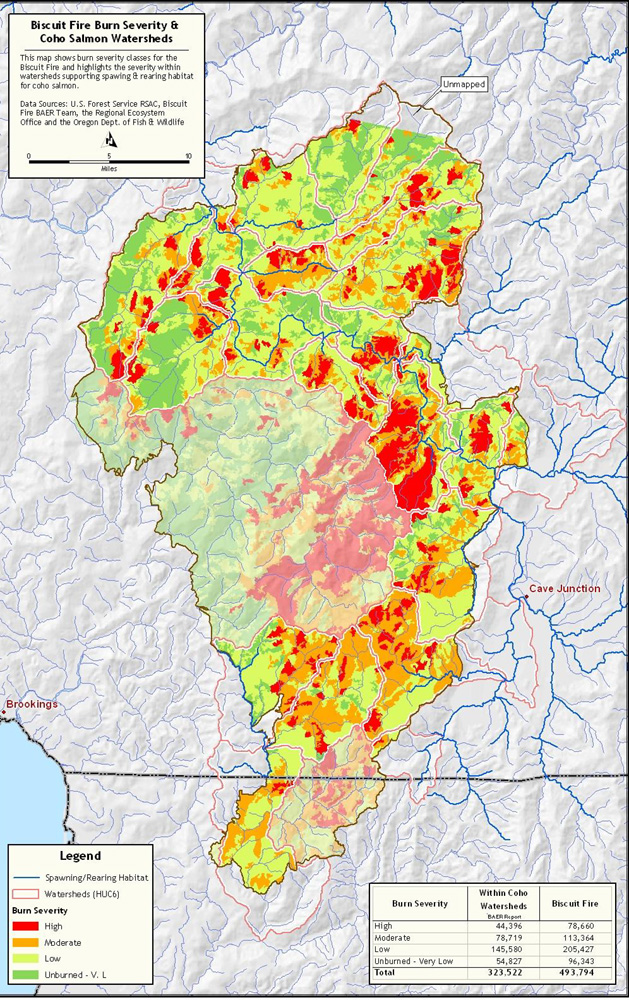 |
Coho Salmon Habitat & Biscuit Fire Severity Map. This map shows the amount of regulated salmon habitat within the boundaries of the Biscuit Fire, and how that habitat may have functioned as fuel during the event. |
|
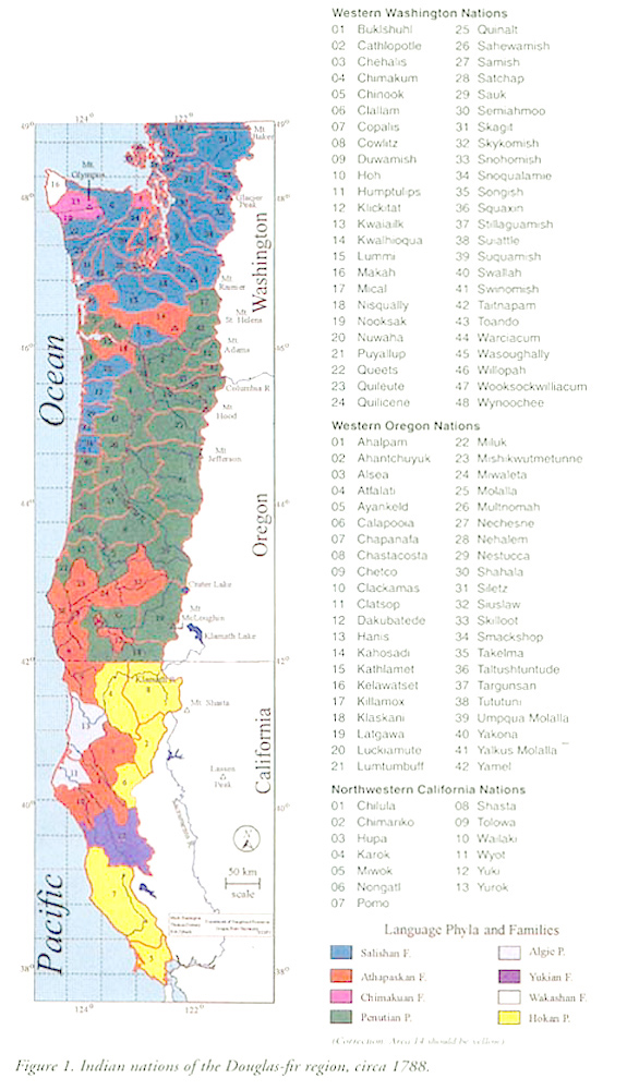 |
Indian Nations of the Douglas-fir Region, ca. 1775. This map shows political boundaries of Indian nations in the Douglas-fir Region at the time of contact with white and black sea traders. Biscuit Fire area shown outside of old-growth, owl, and salmon reserves in three previous maps, is within the current Kalmiopsis Wilderness. In 1775 the Kalmiopsis was within the boundaries of the Chetco Nation, and was managed for bulbs, grains, fruits, nuts, roots, weaving fibers, fuels, construction materials, medicines, dyes, and other native plant products. In 1850 gold was discovered. |
|
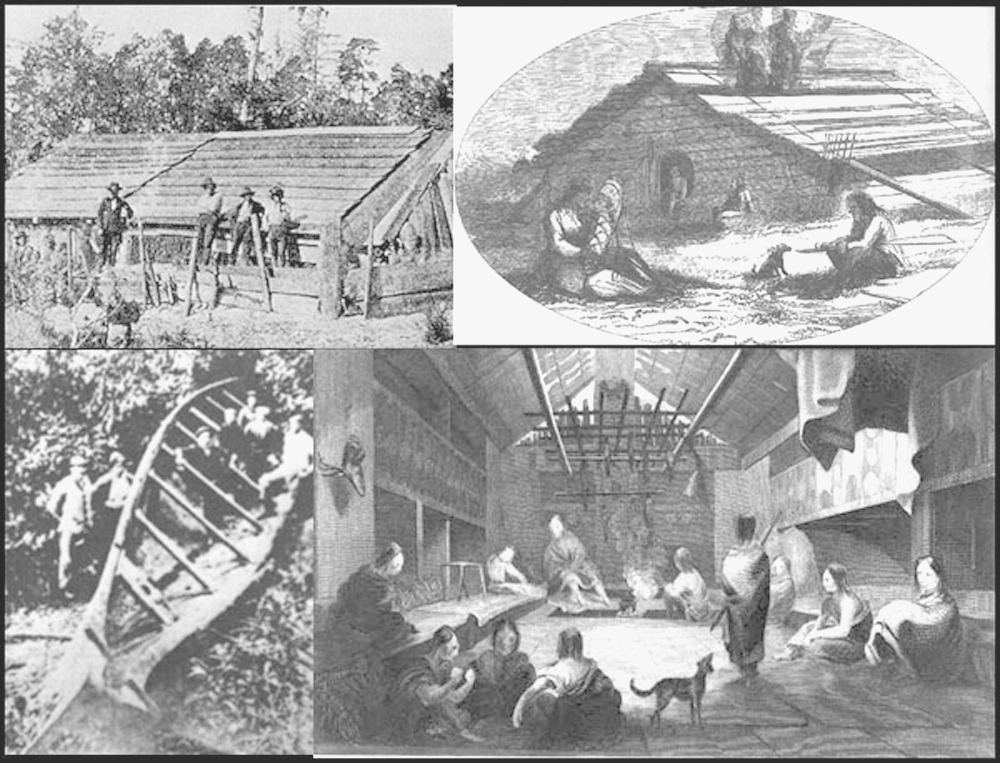 |
Pre-1775 Large Wood Products of Western Oregon. Western Oregon Indian families used large logs to build sea-going canoes and spacious plank homes and halls that could last and be used for centuries. Logs were individually felled, arrived on the tide, or floated downstream from distant hills and mountain sides. | |
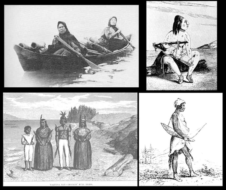 |
Four Pre-1775 Nations of Western Oregon: Salish, Chinook, Yakona, & Kalapuya. These people are representative of cultural differences that existed between western Oregon Indian nations at the time of white contact and during early historical time. | |
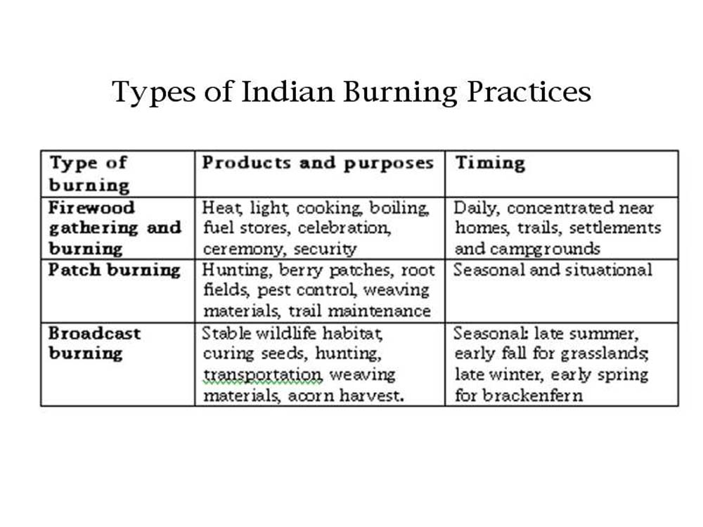 |
Three Types of Indian Burning: Firewood, Patch, and Broadcast. This table (Zybach & Lake: In Review)shows the three principal uses of fire by which Indian families actively managed local croplands and forests on a subbasin scale. Note that each use is clearly driven by one or more objectives. | |
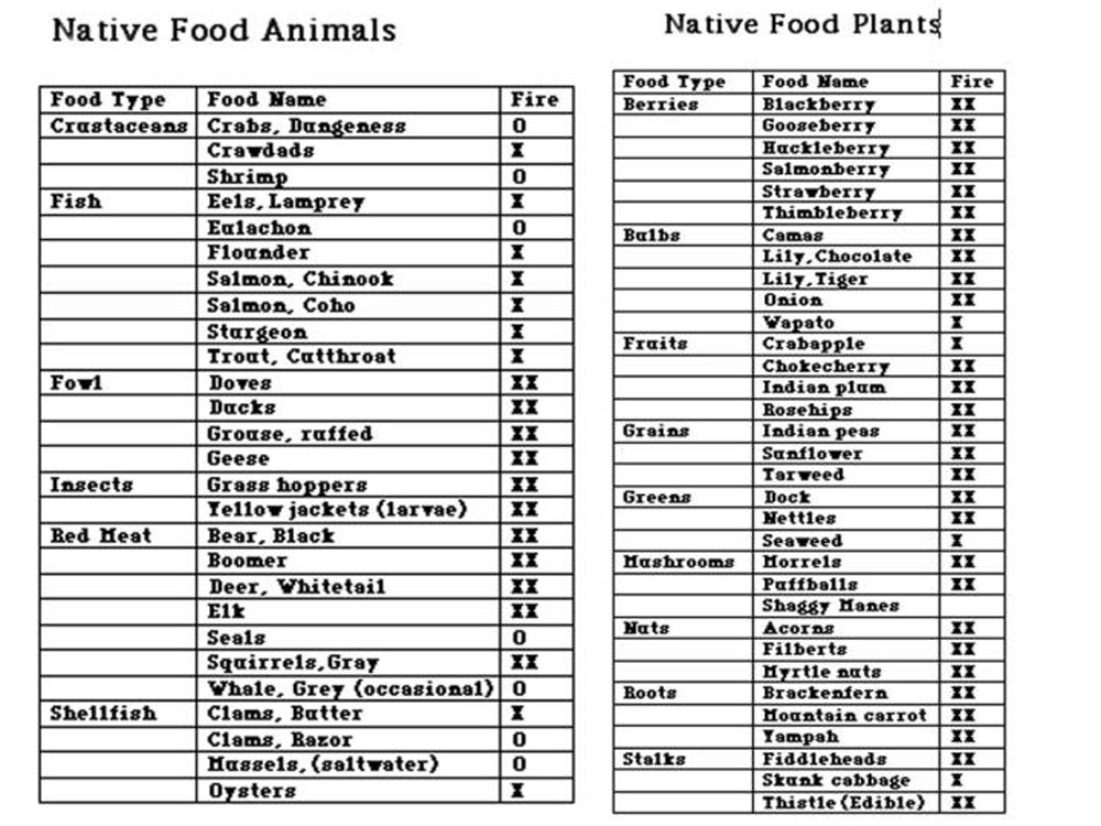 |
Diversity of Native Plant & Animal Food Species That Respond Positively to Regular Fire Use. This table (Zybach 2003) uses "XX" in the "Fire" column to highlight plants and animals regularly used by western Oregon Indian families as a direct or indirect result of regular and widespread fire use. | |
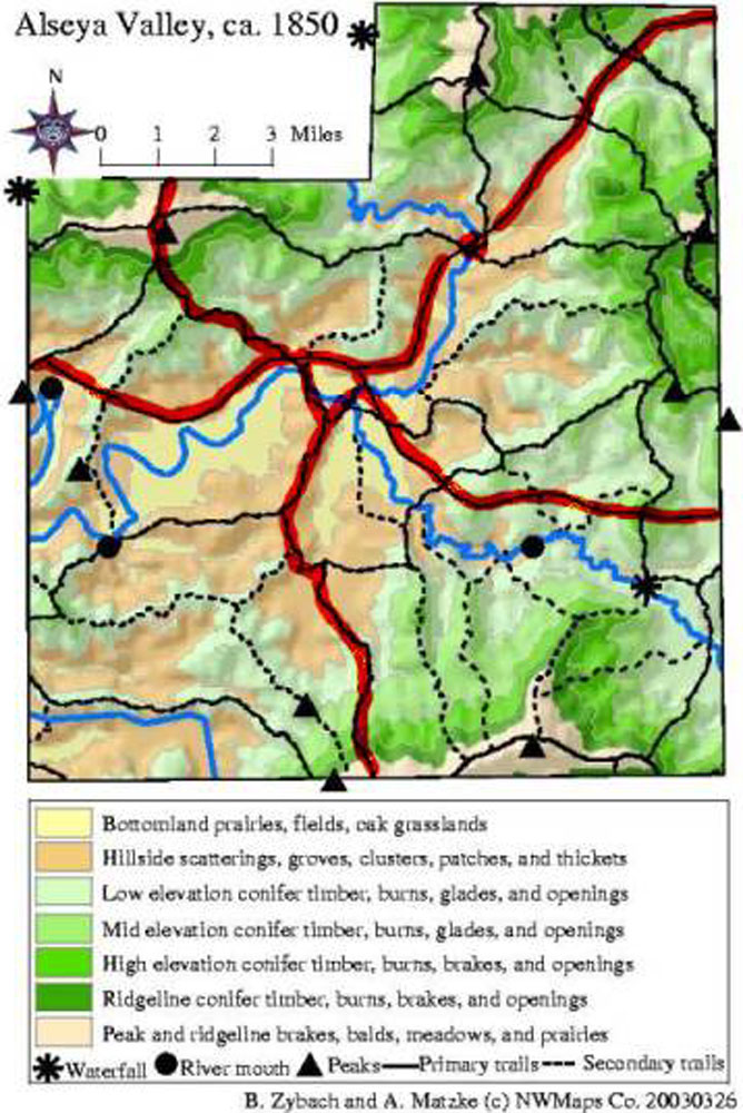 |
Basin-scale Indian Land-Use Patterns, Alsea Valley, ca. 1800. This generalized map (Zybach 2002) of Alsea Valley, Oregon, and its headwaters, shows land use patterns of the Alsi Nation as they existed in early historical time (locally, about 1850). This is a typical Indian land use pattern for people of western Oregon, including those of the Biscuit Fire area. | PDF_Article |
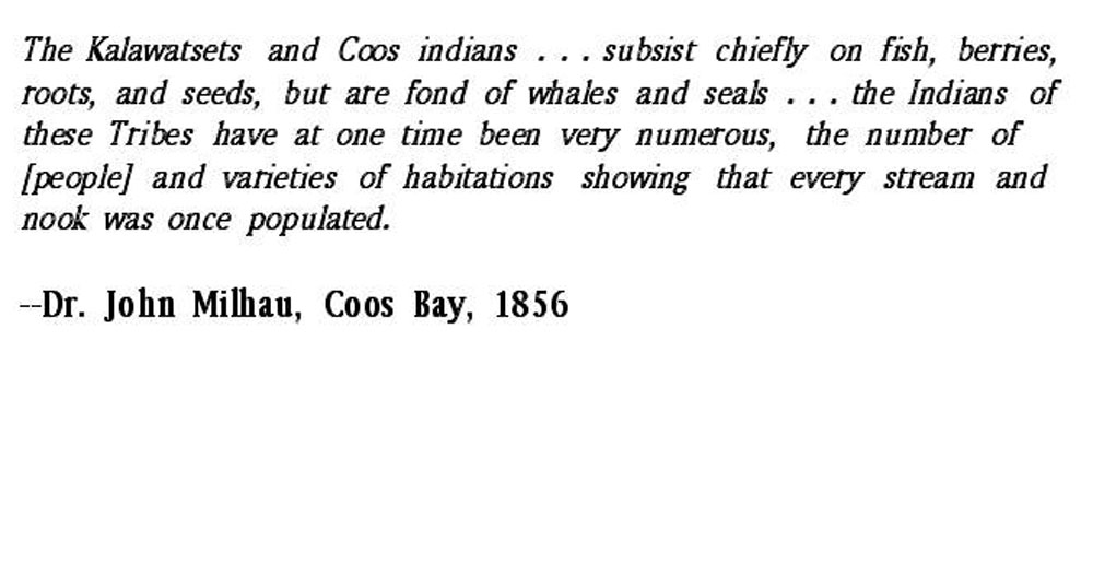 |
Coos and Kelawatset Plagues, pre-1856. Early western Oregon physician remarks on the great reduction of human settlements and populations in the Coos, Coquille, and Umpqua river basins that occured during early historical time. Catastrophic loss of life in local communities due to plagues from the 1770s to the 1830s, was compounded by systematic murderous attacks on surviving SW Oregon and NW California families by immigrant white prospectors and ranchers in the 1850s. Within a few months and years, Chetco Nation had been destroyed and ceded to the US, almost as an after thought. | |
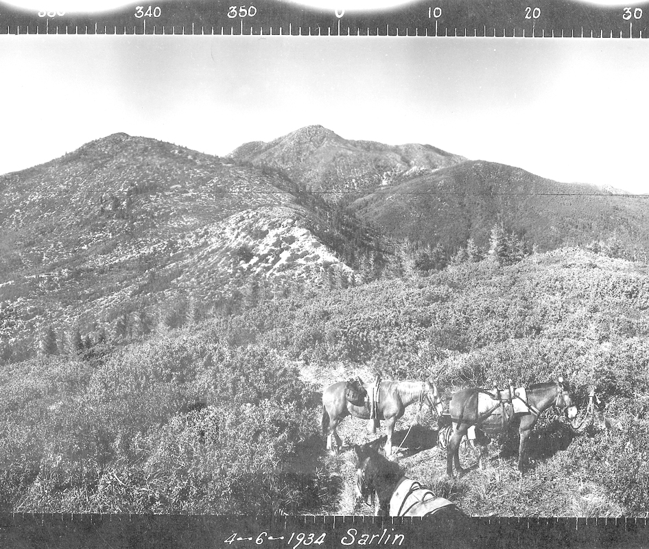 |
Mislatnah Peak (April 6, 1934). View of Kalmiopsis Wilderness, Oregon: from Green Craggies and Big Craggies to the NW, to Pearsoll Peak due east, and Chetco Peak and Vulcan Peak to the SE. See Index Map. See Geology Map. |
|
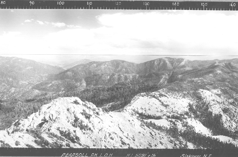 |
Pearsoll Peak (April 21, 1934). Located about one-mile SW of Gold Basin Butte, Oregon, NE of Chetco and Vulcan Peaks, and due east of Mislatnah. See Index Map. See 1957 Quad Map. |
|
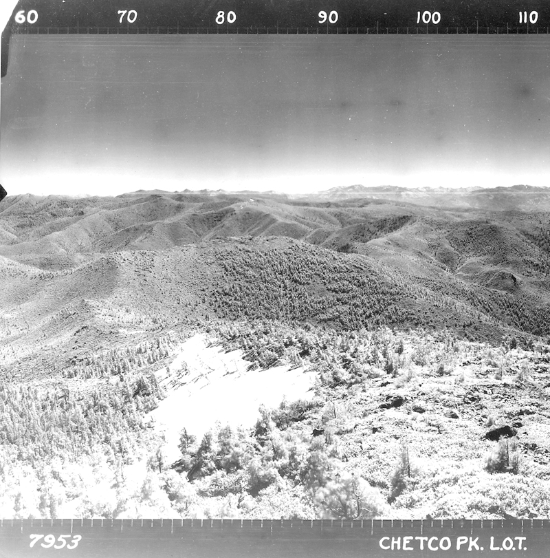 |
Chetco Peak (June 25, 1937). 360-degree view of headwaters of Chetco River; currently within Kalmiopsis Wilderness, Oregon boundaries. This must have been an important place to Chetco people during pre-European contact time. See Index Map. See Homepage. |
|
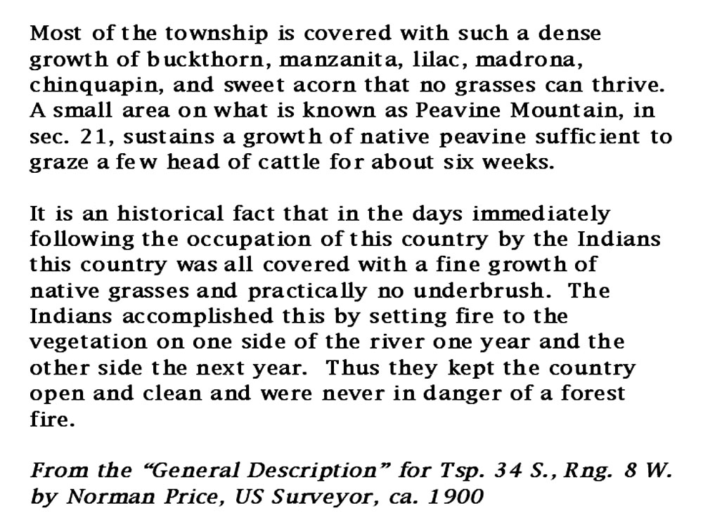 |
General Land Office Survey Record, ca. 1900. Indians historically burned Illinois Valley hillsides in two-year intervals, producing grasslands and fields of peas, and eliminating the danger of forest fires. | |
|
|
Babyfoot Lake Botanical Area: Ecological Values of Active Management | NEXT |
![]()
© 2006 NW Maps Co.