CHAPTER 4.
CATASTROPHIC FOREST FIRE PATTERNS, 1491-1951
The voyage from San Francisco is almost all the way in sight of land; and as you skirt the mountainous coast of Oregon you see long stretches of forest, miles of tall firs killed by forest fires, and rearing their bare heads toward the sky in a vast assemblage of bean poles - a barren view, which you owe to the noble red man, who, it is said, sets fire to these great woods in order to produce for himself a good crop of blueberries. When, some years ago, Walk-in-the-Water, or Red Cloud, or some other Colorado chief, asserted in Washington the right of the Indian to hunt buffalo, on the familiar ground that he must live, a journalist given to figures demolished the Indian position by demonstrating that a race which insisted on living on buffalo meat required about 16,000 acres of land per head for its subsistence, which is more than even we can spare. One wonders, remembering these figures, how many millions of feet of first-class lumber are sacrificed to provide an Indian rancheria with huckleberries.
(Nordhoff, 1878: 338)
The paths of the great forest fires of the last century or two are plainly marked by even-aged stands, consisting to the extent of at least 90 per cent of Douglas fir (if within the preferred habitat of this tree), regardless of the proportion of Douglas fir in the original fire killed stand.
(Munger, 1940: 1).
This chapter provides background on the "Great Fires " and catastrophic "fire years" of the Oregon Coast Range, and compares the nature and character of these events to the precontact Indian burning practices and resulting landscape patterns presented in Chapter 3. Maps, figures, and tables are used to depict spatial and temporal fire patterns, and to illustrate the intensity and dramatic environmental changes represented by these patterns of "stand replacement events".
A. Catastrophic Fires: Background
Catastrophic forest fires, by definition, are wildfires that cover more than 100,000 acres of contiguous forestland during the course of a single event. Catastrophic fire years are calendar years in which more than 100,000 acres of forestland within a given area are burned by wildfire, whether during the course of a single event, or as a result of numerous events.
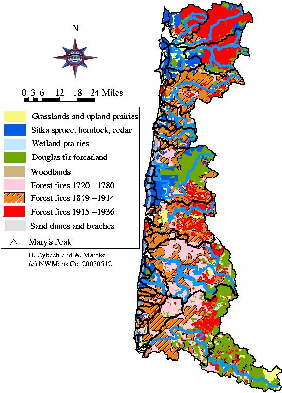
Map 4.01 shows the locations and boundaries of the "Great Fires" of the Oregon Coast Range. The ca. 1770 Millicoma Fire was likely caused by Indians; probably all, or most all, of the remainder were caused by whites (including the Nestucca Fire, blamed on a black settler clearing land near Champoeg; see Morris 1934b). Table 4.01 lists the Great Fires, their likely or known year of occurrence, and their approximate size. Drawings and photographs are used in the following pages of this chapter to show how the burns and reforestation resulting from these events must have appeared to Nordhoff (1878: 338) and other visitors to the region (e.g., Nash 1976; Munger 1916) in the late 1800s and early 1900s. These illustrations also indicate the dramatic change in wildlife habitat conditions (and probably wildlife population numbers, too) that occurs when tens of thousands of acres are burned within a few hours or days time. The next several sections of this chapter provide brief individual profiles of each of the events, as well as a general background on the fires' fuel histories.
Map 4.01 Historic Oregon Coast Range forest fires, 1750-1933.
Table 4.01 Historic Oregon Coast Range forest fires, 1750-1951.
|
Name |
Year |
Season |
Acres |
Authority |
|
Millicoma |
ca. 1770 |
Unknown |
100,000+ |
Smyth 2002: 7 |
|
Yaquina (1) |
1849 |
Aug./Sep. |
500,00 |
Morris 1934b: 322 |
|
Nestucca |
1853 |
Aug./Sep. |
480,000 |
Ballou 2002:67 |
|
Yaquina (2) |
1868 |
Aug./Sep. |
300,00o |
Kirkpatrick 1940:33 |
|
Coos |
1868 |
Aug./Sep. |
126,00o |
Chen 1997: 4 |
|
Tillamook (1) |
1933 |
Aug./Sep. |
340,000 |
Ballou 2002: 77 |
|
Tillamook (2) |
1939 |
|
217,000 |
Chen 1997: 4 |
|
Tillamook (3) |
1945 |
|
181,000 |
Chen 1997: 4 |
|
Tillamook (4) |
1951 |
|
126,000 |
Chen 1997: 4 |
1) Mystery of the 16th Century
Something happened in the Coast Range during the 1500s that resulted in widespread forestation in the 17th century, which in turn likely formed a majority of fuels consumed in subsequent wildfire events throughout the time of this study. Common speculation is that catastrophic forest fires deforested much of western Oregon during that time, including coastal forests (Pyne 1984; Agee 1993). This speculation is based on the assumption that 15th and 16th century fires burned vast tracts of old-growth forests (200 years or greater age), but little evidence exists to support that belief. If such fires did occur, it seems as likely--or possibly even more likely--they burned saplings or second-growth as older trees. Other possibilities include a cessation of widespread Indian burning (see Appendix F). Lightning fires are rare in the region, and historical fires of similar magnitude, such as occurred from 1849 until 1951, were all caused by people (see Appendix G). Were human populations greater in the 1500s than the 1600s, leading to more forest fires and/or more widespread land management practices? A subsequent decline in human populations might reasonably lead to an expansion of existing forestlands, as occurred in the early 19th century. Or could other factors, such as catastrophic winds, diseases, or insect infestations, been a cause? These hypothetical questions are examined in more detail at the conclusion of this chapter.
We know that widespread forestation took place in the Coast Range during the 17th century because, over the course of the last century, hundreds of people counted and recorded the rings of thousands of trees throughout the Oregon Coast Range (e.g., Kimmey and Furniss 1943; Weyerhauser Company 1947; Juday 1976). Tax revenue agents, timber cruisers, forest scientists, resource managers, and graduate students, among others, have done this work. Reasons for counting rings have varied: to measure tree growth; tax timber harvest, record fire events; track seasonal climate changes; or document disease. A common result of these efforts is tree ages have become known and recorded for a significant number of locations throughout the region. Very few of these trees have exceeded 400 years age, and none are known to have achieved 600 years; that is, almost all Coast Range trees described, measured, burned or logged in the last 200 years began to grow sometime after 1600--and the majority of those trees likely began to grow sometime after 1800. In other words, most of the trees known to have lived in the Coast Range during the past 400 years have been second-growth (less than 200 years of age) rather than old-growth, and the majority of trees that have achieved old-growth status spent the majority of their lives as second-growth. For example, over 90% of the Teensma (1981) and Connelly and Kertis (1992) study areas in the western Cascades became forest after 1535, Impara (1997) only has one Coast Range date before 1530, and Weyerhauser Company (1947) has no dates in Coos County before 1565 (see Appendix G). I have similar findings for studies performed on the Alsea and Siletz basins. This fact is of secondary interest to this dissertation, but should have important policy (e.g., FEMAT 1993), scientific (e.g., Agee 1993), and forest and wildlife management (e.g., Shea 1963) implications.
This is an interesting finding for several reasons. The Oregon Coast Range contains many of the largest and fastest growing species and specimens of forest trees in the world (CITE). Douglas-fir, Sitka spruce, western hemlock, redcedar, black cottonwood, red alder, and white oak all tend to live much longer in other regions of the Pacific Northwest (e.g., Franklin 1981), often taking many additional decades or centuries to achieve similar heights, diameters, or volumes in size. Douglas-fir, for example, is known to reach ages of 700, 1000, or even more years in areas of the western Cascades (e.g., CITE), Olympic Peninsula (Henderson, et al. 1987), or Vancouver Island (Schmidt 1970: 108), yet the height, diameter, and/or volume of those trees is not significantly different than the largest, though much younger, Coast Range trees (CITE).
Fig. 4.01 shows examples of old-growth trees established in precontact time. The upper left hand drawing of sailors measuring an old-growth Douglas-fir near Astoria was made in 1841 by Agate (Wilkes 1845), using a method in which a reflected image is traced. The method produces a drawing that is nearly as accurate as a photograph, particularly in regard to scale. In 1825, Douglas measured a barkless, three-foot high stump behind Fort Astoria that was 48-feet in circumference, which he noted had been logged "to give place to a more useful vegetable, namely potatoes" (Meany 1935: 53). The upper right photograph (B. Zybach 2003) shows a Douglas-fir located along the ridgeline "Indian Trail to Tidewater" surveyed in 1856 (see Map 2.11). The heavy lower limb structure indicates that the tree grew in the open, thereby reducing risk of crown fire. The leeward side of such trees provide good protection from wind and rain. In precontact time this tree would have been clearly visible from much of Alsea Valley and the surrounding landscape, adding potential value as a landmark or meeting site. The lower left picture is of old-growth oak (B. Zybach 2003), located near the town of Alsea (see Fig. 2.03) in an area containing numerous precontact artifacts (personal observation and informal interviews with owners and adjacent residents). Oak were prized by precontact Indians for many reasons, including their ability to produce acorns. In Coast Range areas where oak are left undisturbed by fire, grazing, mowing, plowing, logging, and/or other management process, they are soon replaced by competing conifers (Sprague and Hansen 1946; Zybach 1999: 102-117). The lower right hand corner (N. Lapham 2003) shows another, nearby, old-growth oak being threatened by second-growth Douglas-fir, several centuries younger in age. Many Indians highly prized oak trees and groves, and viewed most conifers as invasive weeds (Thompson 1991: 33). These trees are typical of certain precontact old-growth forms and species and demonstrate potential "functions" in earlier landscape patterns, dating to the beginnings of this study period.
Fig. 4.01 Precontact Douglas-fir and white oak old-growth, 1841-2003.
Fig. 4.02 (Williams 1912: 137) shows the change of values toward old-growth trees that accompanied the replacement of
Indians with whites across the Coast Range landscape. Large, sound conifer trees with a minimum of lower limbs were highly
prized by early loggers and sawmill owners, particularly if they were located near a major waterway or could be readily
accessed via railroad construction. These trees, as with those pictured in Fig. 4.01, likely date to the 16th or 17th century; a
key difference is they were allowed to grow in an absence of human disturbance, rather than be dependent on it.
Fig. 4.02 Logging of Clatskanie River basin, ca. 1900.
Shortly after W.W. II, in 1945 and 1946, Weyerhauser Company did an inventory of its land and timber holdings in Coos County, principally within the Millicoma River basin (see Map 1.03). Foresters traversed grids across the landscape, boring about 1500 trees, mostly Douglas-fir, and counting the rings, over more than 100,000 acres of forestland. They also noted species, diameter, the length of clear boles, and other measures of interest to timberland managers. Most of the trees, covering a swath more than 90,000 acres in size, were large second growth of the same age (Weyerhauser Company 1947): about 180 years old. One of the foresters who worked on the project, in concert with his peers, concluded the stand dated to a single catastrophic fire, that occurred about 1765 (Smyth 2002: 2-4). A few older clumps of trees, dating to the 1720s, were also included in the inventory and assumed to be possible seed sources for the younger stand. Adjacent stands of timber, notably the so-called 28,000 acre Pillsbury Tract (Shea 1963), were also possible seed sources, and dated to the 1600s.
The Weyerhauser timber cruise provides the first compelling evidence of a Coast Range catastrophic fire that dates to precontact times, although it remains possible the trees became established following some other form of disturbance. Fig. 4.03 (Smyth 2001: 53) shows a portion of the Millicoma stand as it appeared to foresters in the 1940s. Note that snags and large woody debris in this area appears to be from younger trees in the stand, rather than provide evidence of an earlier population. It is also possible that the ca. 1720 trees represent an initial fire in the stand, and that the 1765 component represents a reburn over much of the original fire's extent. Either--or both--date(s) would satisfy Morris' (1934b: 314) observation:
When land in western Oregon and western Washington is deforested by fire or cutting and then left unmolested, within a few years it is clothed with a new stand of trees almost uniform in age.
Fig. 4.03 Millicoma Fire reforestation, ca. 1946.
The Weyerhauser cruise covered most of the northern part of the Millicoma stand; the southern part extended into land
that became Elliott State Forest, most of which became established following the 1868 Coos Fires. Jerry Phillips, who worked
on the Elliott as its Chief Forester for nearly his entire career, mapped in the southern part of the ca.1765 stand (Phillips 1988), to an approximate boundary between the two events. These efforts conform fairly well to the 1936 Andrews-Cowlin map (see Map 2.10) as an extensive stand of large second growth. Smyth (2000: 2) gives a figure of about 200,000 acres for the fire, but doesn't acknowledge 28,000 acres of older trees (Shea 1963: 4) or directly account for another 80,000 acres that wasn't included in the 1945-1946 Weyerhauser cruise. Phillips (1988) shows the ca. 1765 fire as bordering directly on the 1868 fire, so there is no telling how much of the original boundary was burned again at that time. My best estimate from the cited sources is the original Millicoma Fire, whether occurring in 1720 or 1765, was about the same size as currently given for the 1868 Coos Fire: 125,000 acres. Reasonable speculation is the number 1765 is an average (I have been unable to obtain actual records from the cruise) and that the year of the principal fire is actually sometime between 1710 and 1760. One condition that would help resolve the issue of dating is whether the 1720 component existed in clusters, or were somewhat evenly distributed throughout the entire 1760 stand. Smyth further speculates the fire was caused by Indians and traveled from the northeast to southwest. Phillips' and Weyerhaeuser's maps seem to agree with the burn pattern, and general Coast Range fire history supports the likely cause.
The Yaquina Fire may be the largest of the Great Fires. Morris (1934b: 322) says it extended southwesterly from the South Fork (Rock Creek) of the Siletz River to the mouth of the Siuslaw River (see Map 1.03). William Smith (see Appendix C), an Alsi Indian, seems to be the only reliable eyewitness of record to this event (Frachtenberg 1920), and he agrees with Morris on the time (about 1849) and southern extent (Siuslaw River). Talbot (Haskin 1948) was in the area in late August, 1849, when he noted heavy smoke moving west from the area of the Marys and Yaquina river headwaters area, through early September, when he left Alsea Bay, crossed the Yaquina and Siletz estuaries along the coast, and returned to the Willamette Valley via the Salmon River. If the fire did occur in 1849, which seems likely, it must have covered most of its extent in September, after Talbot had traveled through its interior--which also seems likely. It may have also crossed the Siuslaw River and ended near the Umpqua River; if not in 1849, then maybe in 1857 or 1868 (Morris 1934b: 322).
Both Talbot and Albert (1848), who preceded him along the same general route in 1848, but in reverse, noted fairly large burns that had already occurred near the northeast extent of the Yaquina Fire:
[Talbot] Our road today [August 26, 1849] . . . [was] much obstructed by fallen trees and thick brush. We passed through one tract of burnt forest several miles in extent where the little trail which we followed, indifferent at the best, was often completely broken up, and we were compelled to have recourse to our axes to make a way through the heaps of charred logs. We descended, after a toilsome day’s journey, into a grassy valley, about half a mile in length, watered by a fork [Rock Creek] of the Celeetz [Siletz] river, in which we encamped, having made nine miles (Haskins 1948).
[Albert] The Celeetse [Siletz] prairie is level, rich, and the fern is eight or ten feet high. The prairie is surrounded by timber . . . Coming up the Celeetse river, we passed prairie bottoms or plains . . . The Celeeste river has many forks, but only two principal ones. The main river is larger than Pudding river . . . the timber, however, is not very good, having been badly burnt for some miles around the N. E. portion of it. The path from the Celeetse prairie is rugged, full of logs, &c. (Albert 1848: 1).
The burned logs may have resulted from clearing fires for the horse trail constructed recently by Klickitats from Kings Valley (Luckiamute River) to the Siletz and Yaquina rivers. This route follows the northern boundary of the Yaquina Fire (CITE). Both journalists noted extensive burns, brakes, prairies, downed logs, and big trees, but no evidence of the subsequent Great Fire. Munford (Nash 1976: 281) quotes James Blodgett:
As a boy, I knew this country well. A great fire in 1850, while my great-grandfather was in California, destroyed about 150 square miles [100,000 acres] of virgin forest. The fire stopped along a line approximately from Hoskins to Blodgett to Marys Peak. What is again dense forest was, in 1877, open fern-covered ground interspersed with the skeletons of burned trees. Burnt Woods [see Appendix B] takes its name from this feature.
I confirmed this story with Blodgett on August 23, 1984. He conceded the fire may well have occurred in the fall of 1849. His ancestors had been among the first to travel to the gold fields in California, having left in July, 1848. There, his grandfather (also named James) was born on August 12, 1850. The family returned to Oregon in time to be counted in the October 7, 1850 Oregon Territory census ["Dwelling #148"], when they had been "amazed" to see that "the entire area from Marys Peak to the ocean had been burned clean by fire" and had become a "sea of snags". They were also gratified to note their homestead, "Blodgett's Valley", to the west of Philomath, had been spared. Blodgett claimed this story had been told to him by his father in the 1920s, who had been told the same story by his parents in the 1890s. In sum, the Blodgett's had returned to their homestead on the eastern boundary of the Yaquina Fire sometime between late August and early October, 1850, when they found a fire had destroyed almost all of the timber between their home and the ocean. Talbot had noted large fires in the area in the fall of 1849, when the Blodgett's were still in California, and the Blodgett family history made no mention of smoke or fire in 1850--only burned land and snags. Therefore, an August/September, 1849 date and an east to west (east wind) burning pattern seem to be the most likely attributes of the fire.
Fig. 4.04 (Fagan 1885) shows results of the Yaquina Fire near Toledo, along the Yaquina River, a few miles east of Yaquina Bay. Note the location of Marys Peak in the background. Talbot noted on September 2, 1849 (Haskins 1948):
Should it be satisfactorily ascertained that ships may come in [to Yaquina Bay] with safety, this harbor will become exceedingly valuable, as it is surrounded by a country covered with forests of the finest kind of timber, has good mill-seats, and roads could be constructed which would afford a near market for the produce of the upper Willamette.
While traveling through the same area in 1848, Albert (1848: 1) noted:
The Yac-quin-na harbor, they [some local Indians] said, was long and deep, and also deep at the mouth . . . The land from the Yac-quin-na is rolling--in fact, mountainous, with heavy timber, and is really the prettiest building timber we have ever seen--containing many springs, and small prairies covered with fern.
Because a second (or third) major fire occurred throughout the Burn in 1868 (Fagan 1885; Bensell 1978), the "rolling" land behind Toledo in Fig. 4.04 remained largely unforested into the 1880s. A related factor is the Yaquina Tract was removed from the Coast Indian Reservation and opened to white settlement in 1865 to provide land for Civil War veterans, among others (CITE). The burned land was subsequently used for grazing, a use that extended well into the 1930s (Wakefield 1989: personal communication), and one that would have further reduced the likelihood of reforestation.
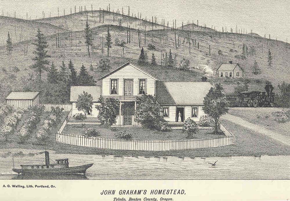
Fig. 4.04 Yaquina Burn, Toledo, Lincoln Co., Oregon, 1885.
The southernmost extent of the fire, as noted above, was likely near the mouth of the Siuslaw River. This location was described by Smith (see Appendix C), whose father and uncle traveled south from Heceta Head during the aftermath of the fire, and described their journey to him and other family members on their return:
Then they [Smith's father and uncle] started. Where there was a mountain [possibly Cape Mountain], that place there did not burn. So they two kept on going on that trail, and they arrived at where there was a place (covered) with grass. And only there did the fire reach. Then they two ascended. Now it was gradually getting light all over [the smoke was beginning to clear, after darkening the skies for about 10 days]; just a little (light) showed far away. At last they came below, whereupon they two started to walk on that beach. Then they two kept on going along the beach. Everywhere even the blossoms of the highest trees had burned down, (as could be seen) after the water came with them to the beach. Now not long (afterward) they two saw a bear walking along the edge of the water, just partially burned. At last they two arrived at the mouth of the Siuslaw River. All the pine trees (there) were partially burned. Only ashes (could be seen) all over, because all the pine trees had caught fire.
Smith's description conforms very well with subsequent maps of the area (see Map 4.01), which show the fire burning all the way to the coastline--right to the strip of shorepine noted by Smith that borders the beach--at the mouth of the Siuslaw River. Whether the fire continued southward to the Umpqua River, or whether the burned land between the Umpqua and Siuslaw dates to the 1868 Yaquina reburn or to the Coos Fire of the same year, is unknown. (It is probably also a relatively unimportant designation, except to those interested in determining a common boundary between the two fires in order to assign acreage to one or the other, or for some similar purpose.)
The Nestucca Fire is one of the least documented and most storied of the Great Fires. Munger (1944: 342) states there was only a single eyewitness accounting of the fire ("reported many years later to a now anonymous writer by Dick Harney, chief of the Nestucca tribe") that "certainly spread from east to west" and covered "300,000 or 375,000 acre expanse of the country's finest timber". According to Morris (1934b: 321), the fire extended from the Nestucca-Trask basins divide south to Siletz Bay, with a marked difference between the northern and southern portions of the resulting burn. Munger (1944) attributes the differences to subsequent land management history of grazing and land clearing, but the presence of precontact Indian prairies, balds, brakes, and berry patches undoubtedly affected fire extent, afforestation, and reforestation patterns. Cascade Head, for example, was noted by early coast surveyors as being identifiable by having only three old-growth trees and no snags on it (McArthur 1856), yet the area had become fully stocked by 1900, and was the made site of a 1988 OSU "Starkers Lectures" old-growth field tour because of the large size and apparent great age of its trees (CITE).
The oldest conifers on the 1935-1988 Cascade Head growth and yield study were established in 1852 (CITE). In 1940, the eleven "practically even-aged, uniform in stocking" growth study plots average 89-years old (Munger 1944: 344); that is, they were established sometime around 1850. Whether the new forest plots dated to a catastrophic fire or to a cessation of Indian burning is difficult to determine. Several of the plots still exist, but none of the literature mentions the existence of older trees, snags, stumps, or logs within their boundaries. Arthur (1848: 1), Talbot (Haskin 1948), and Vaughn (1923) were through the area in the late 1840s and early 1850s and made no mention of a fire. Ballou (2002) gives a date of 1853, but Vaughn probably traveled through the area a year or two after that time, without mentioning a large-scale burn. Morris (1934b) lists 1857 as a year of much smoke, and I suspect the principal Nestucca fire may have occurred at that time, with boundaries being extended in 1868.
Fig. 4.05 shows photographs of portions of the great Yaquina and Nestucca burns as they appeared around 1900 (Gannett 1902). Note the scattered "parent trees" that survived both fires and were likely seed sources to the reforested stands of the 20th century. Also, note the cleared area of land claimed by an early settler in the lower picture. The lack of snags in the clearing indicates a likelihood of regular precontact use by local Indians, and the presence of young saplings in the same area indicates the likely cessation of such use. These patterns of widespread snags, scattered surviving trees, tree-less prairies and openings, and the presence of young trees throughout are typical of much of the Coast Range. Also, note the similarity in size and distribution of Yaquina Burn snags in Figs. 4.04 and 4.05.
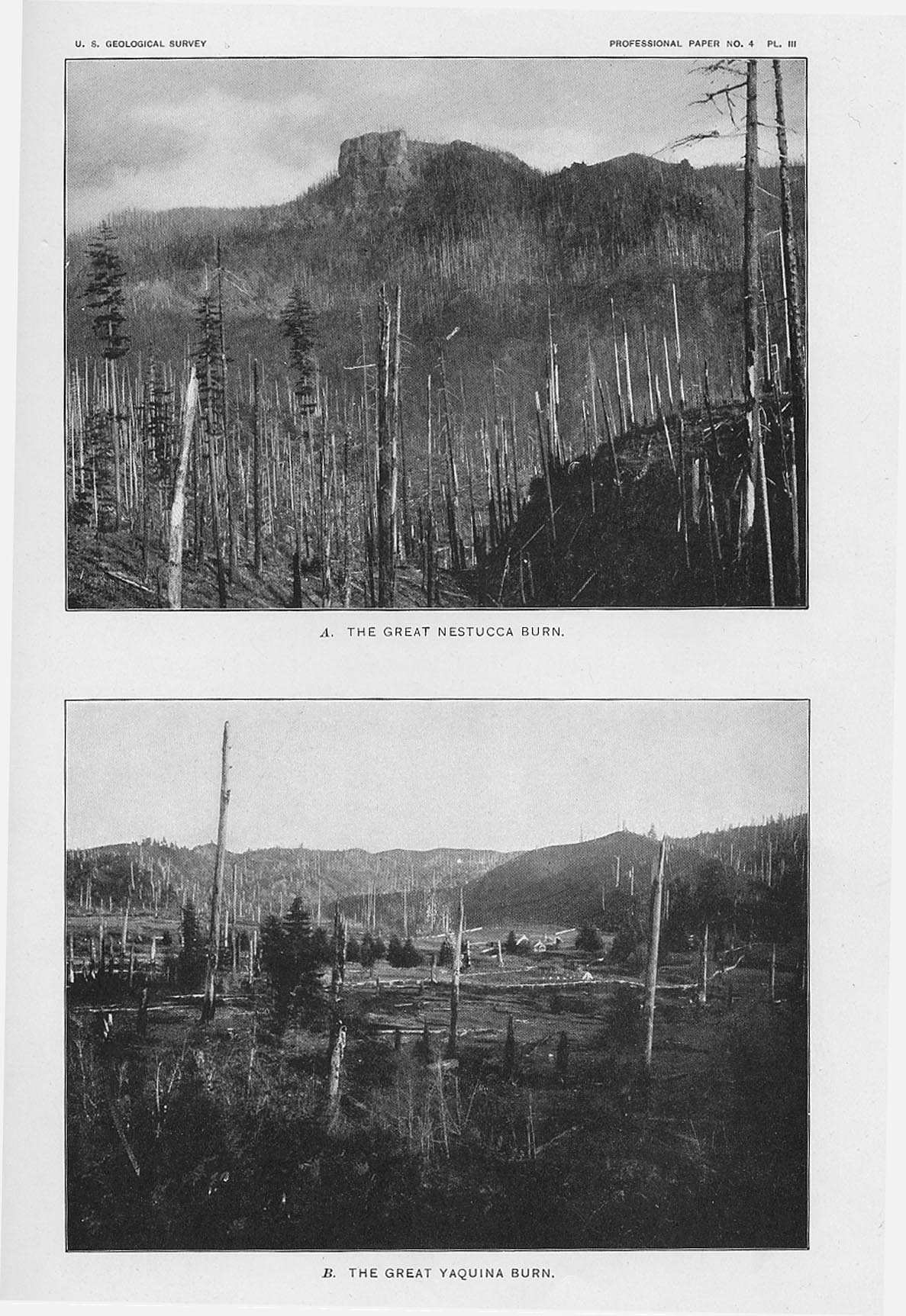
Fig. 4.05 Yaquina and Nestucca burns, ca. 1902.
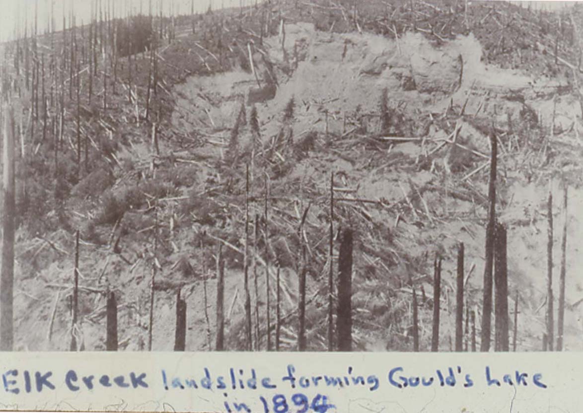
Fig. 4.06 Coos Burn, Elk Lake slide, 1894.
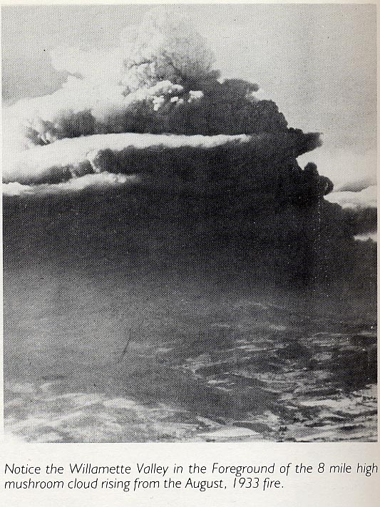
Fig. 4.07 Tillamook Fire mushroom cloud, 1933.
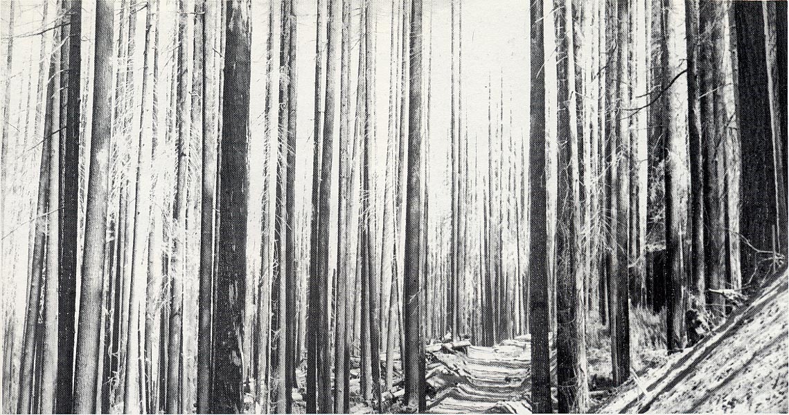
Fig. 4.08 Tillamook Burn snags, ca. 1935.
I have used the 100,000 acre of burned forestland "catastrophic fire" measure as a standard for historical fire years,; i.e., any year in which 100,000 acres of forest burned in western Oregon, I considered a "fire year" for the region. To be conservative, I have listed all Oregon Department of Forestry (ODF) records for years in which at least 75,000 acres are listed (Ballou 2002). This is due to inconsistencies in acreage measures and because there is uncertainty whether the ODF records include fires on federal lands for all yours (Ballou 2003: personal communication). For prehistoric fires, I have used tree ring studies to identify "severe" fire years. I have paid particular attention to Impara's (1997) study because: 1) it is located in the Coast Range, 2) he generalizes his findings for the entire Coast Range, and 3) it extends well into the recent (historical) past (see Appendix G).
Such fires are almost invariably caused by either people or lightning; Agee (1993: 25-26) claims more than 99% of all forest fires worldwide are started by one or both of these methods. In the Oregon Coast Range, there is no record of a catastrophic fire or catastrophic fire year caused by lightning. People, rather than lightning or other causes, have been responsible for the vast majority of wildfires in this region (Kirkpatrick 1940; Bonnicksen 2000: 392), whether measured by acreage or number of events (Ballou 2002). Lightning has been rare in the region throughout recorded history (see Chapter 1), and fires started by lightning are even more unusual (see Map 1.07; Kirkpatrick 1940; Morris 1934a). When lightning does occur, it is often accompanied by heavy rains and tends to put fires out, rather than start them (Morris 1934b). Thus, wildfire patterns preceding white settlement in the mid-1800s can reasonably be attributed almost entirely to Indian burning practices. Subsequent wildfires--particularly those occurring after 1843 (Carey 1971: 311), when Indian populations were low and restricted to a few wandering bands and minor communities--can likewise be attributed almost entirely to fires set by whites. (It is interesting to track how public and scientific opinions have changed regarding the sources of ignition for catastrophic Coast Range fires in the last 150 years, and the apparent racial bias attached to these perceptions. During the 19th century period of their occurrence, they were often attributed to Indians (e.g., Nordhoff, 1878: 338); more recently, they have mostly been ascribed to lightning (e.g., Agee 1993; Whitlock and Knox 2002); in one instance in which neither Indians or lightning were blamed, a black settler was held accountable (Morris 1934b), even though there were hardly any black people present in Oregon at that time.)
1) 1491-1825: precontact evidence
The only evidence of Coast Range catastrophic fire years in precontact time are Impara's (1997: 212) "high severe fire years" based on tree ring studies, and inferred severity, based on large-scale stands of even-aged trees, such as the Millicoma Fire, or widespread stands of similarly-aged trees, such as date to the 1600s. Note that Impara's (1997) two greatest fire years, 1852 and 1871, are both three years after the historical fire years of 1849 and 1868. Either the events were a lot more localized than he thought (bringing into doubt the utility of his 1880s and pre-1851 fires), or his methodology is adding a few years to his findings. This is an important point, because he uses the absence of personal findings in the early 1900s to conclude that federal fire suppression policies all but stopped fires (except for Tillamook, which he didn't find a record for) after 1910.
2) 1826-1848: early historical accounts
Background on the Great Fires was given in the first part of this chapter. Historical quotes and photographs were used to document specific events, and also to demonstrate the relative poor quality of information available on the topic for historical time. One consequence of poor record keeping is that it is difficult or impossible to identify specific years in which fire was widespread throughout the region, but in which no single event dominated. A combination of public awareness regarding forest fire destruction, modern technology (photographs, movies, telephones), and creation of large federal forest reserves in the 1890s, specifically intended to be protected from fire, soon changed the quality and focus of both news gathering and record keeping. In 1902, and then again in 1910, forest fires occurred throughout the entire Pacific Northwest, including the Coast Range. News media reported on these fires in detail, and state and federal organizations soon formed for the specific purpose of reducing wildfires and/or "battling" to control them (Pyne 1982: 239-321). The fires of 1910, and particularly the fires in the Rocky Mountains of Idaho and Wyoming that year in which millions of acres burned and dozens of firefighters died, focused attention on the US Forest Service and led to a national resolve to intensify wildfire control strategies (ibid.; 239-241). In Oregon, county fire control associations were established, funded at first by voluntary contributions of affected landowners. The Oregon Department of Forestry began consolidating records kept by the county crews in 1911 (Ballou 2002) and, in 1914, State Forester Elliott authorized and directed the assemblage of a statewide Fire Map (see Map 2.05).
Appendix G includes a summary of the forest fire record assembled for western Oregon by the Oregon Department of Forestry from 1911 to 2002, derived from state and county records. Table 4.02 lists that summary. Note that approximately seven times as many fires for this time period were started by people, rather than lightning. Because the large majority of western Oregon lightning strikes, lightning storms, and lightning-caused fires in western Oregon from 1925-1996 are recorded in the Klamath-Siskiyou mountains of southwest Oregon and in the western Cascades, the ratio of human-caused to lightning-caused forest fires in the Coast Range is likely much larger than the 7:1 ratio shown for the entire area.
Table 4.02 Historic western Oregon forest fire years, 1849-2003.
|
Year |
Acres |
People |
Lightning |
Authority |
|
1849 |
500,000+ |
Yes |
|
Morris 1934b: 322 |
|
1853 |
480,000 |
Yes |
|
Ballou 2002: 67 |
|
1868 |
300,000 |
Yes |
|
Kirkpatrick 1940:33 |
|
1902 |
170,000 |
Yes |
|
Ballou 2002: 67 |
|
Total |
|
|
|
|
|
1910 |
51,000+ |
Yes |
|
Kirkpatrick 1940: 35 |
|
1914 |
146,000 |
1,107 |
147 |
Ballou 2002: 77 |
|
1915 |
109,000 |
1,170 |
85 |
Ballou 2002: 77 |
|
1917 |
258,000 |
1,468 |
177 |
ODF 1994; Ballou 2002: 77 |
|
1918 |
184,000 |
813 |
139 |
Ballou 2002: 77 |
|
1919 |
143,000 |
963 |
181 |
Ballou 2002: 77 |
|
Total |
|
|
|
|
|
1922 |
179,000 |
1,312 |
95 |
Ballou 2002: 77 |
|
1924 |
252,000 |
1,577 |
311 |
Ballou 2002: 77 |
|
1926 |
208.000 |
996 |
150 |
Ballou 2002: 77 |
|
1928 |
104,000 |
913 |
154 |
Ballou 2002: 77 |
|
1929 |
298,000 |
1,355 |
117 |
Ballou 2002: 77 |
|
Total |
|
|
|
|
|
1931 |
188,000 |
1,536 |
85 |
Ballou 2002: 77 |
|
1932 |
333,000 |
1,601 |
87 |
Ballou 2002: 77 |
|
1933 |
341,000 |
943 |
239 |
Ballou 2002: 77 |
|
1936 |
225,000 |
1,265 |
139 |
Ballou 2002: 77 |
|
1938 |
80,000+ |
957 |
188 |
Ballou 2002: 77 |
|
1939 |
309,000 |
965 |
294 |
Ballou 2002: 77 |
|
Total |
|
|
|
|
|
1945 |
253,000 |
532 |
333 |
Ballou 2002: 77 |
|
1951 |
126,000 |
850 |
104 |
Ballou 2002: 77 |
|
|
|
|
|
|
|
1987 |
89,000 |
976 |
605 |
Ballou 2002: 77 |
|
1996 |
189,000 |
4 |
9 |
Coyle 2002 |
|
2000 |
110,000 |
8 |
4 |
Coyle 2002 |
|
2002 |
500,000 |
|
|
Ballou 2002: 67 |
4) 1911-1951: fire suppression policies
Recent occurrences of catastrophic fires in southwest Oregon have been blamed, in part, on dangerous fuel build-ups resulting from federal and state fire control policies adopted following the 1910 fire year. Although fire suppression policies may be a factor in such fires, there is little evidence to support this claim for Coast Range forestlands. Table 4.02 shows 16 catastrophic fire years in the three decades immediately following 1910 (1911-1940), or more than 50% of the years during that time period. From 1912 to 1951 the total is 18 fire years, or 45% of the 40 years following adoption of these polices. Then, from 1952-1986, there is a string of 35 years without a single catastrophic fire or catastrophic fire year for all of western Oregon, at which time (1987) the Silver Complex fire took place in southwest Oregon. For the Coast Range, the sudden reduction in catastrophic fire seasons and events is even more striking--not a single event in more than 50 years since 1951, continuing to the present time (2003). The record, then, is a dramatic and sustained increase in numbers and events of catastrophic fire seasons for the 40 years following fire suppression, and then an apparent elimination of such events from that time to the present. "Fire suppression policies", therefore, doesn't begin to explain this history. Something that occurred shortly after W.W. II seems to more likely answer this abrupt change in the environment. Possibly a combination of factors: e.g., public education, improved firefighting technologies, dramatic increases in road-building and clearcutting during the late 1940s and into the 1970s, increased reliance on fossil fuels and electricity for heating homes, and other conditions seem to be more likely causes of such change.
The question now is: Does the abrupt change in Coast Range catastrophic fire history signal a generally permanent departure from past wildfire events, or is it the "lull before the storm" in which fuels rebuild to hazardous levels and the area once again becomes the stage for uncontrollable wildfires of historic proportions?
The following maps show patterns of burning and logging that occurred throughout the Coast Range during historical time. GIS is used to construct subregional maps to directly compare catastrophic fire patterns with Indian burning patterns of trails and openings, as described and mapped in Chapter 3. The comparison of patterns, made possible by GIS methodology, constitutes much of the focus of this research.
1) North: Columbia River old-growth
The northern Oregon Coast Range has long been recognized as an area of giant trees (see Fig. 4.01) and logs (Fig. 4.02). Clark, for example, noted on November 9, 1805:
At 2 oClock P M the flood tide came in accompanied with emence waves and heavy winds, floated the trees and Drift which was on the point on which we Camped [in present Washington State, across the Columbia River from modern-day Astoria] and tossed them about in such a manner as to endanger the canoes verry much, with every exertion and the Strictest attention by every individual of the party was scercely sufficient to Save our Canoes from being crushed by those monstrous trees maney of them nearly 200 feet long and from 4 to 7 feet through.
Kimmey and Furniss (1943: 8) located almost all of their western Oregon old-growth study plots in the northern Coast Range, even though their definition of old-growth was very conservative by today's standards: "mostly over the age of 400 years, and with a usual d. b. h. ["diameter at breast height", a measure usually made 4 1/2 feet above the level surface of the ground] of about 40 to 100 inches or more (ibid.: 4). Although the age of Clark's and Kimmey and Furniss' trees are unknown, the diameter measures are nearly identical. The presence of such large trees, of course, indicates the absence of stand replacement events, such as catastrophic fires, for long periods of time. The proximity of such trees to the Columbia River increased their commercial logging value as they could be readily transported long distances by water to processing centers in California, or to international ports throughout the Pacific Ocean (Benson 1964).
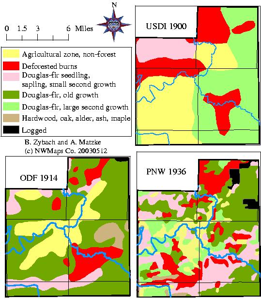
Despite the presence of vast tracts of giant trees, however, wildfire, wind, insects, and diseases were major disturbance factors in northern Coast Range forests. Map 4.02, for example, is part of an extensive timber cruise of Clatsop County lands in Tsp. 4 N. (see Map 2.01). This cruise map of a 640-acre section by Wherry (Cabe[?] et al. 1913) is representative of the types of details mapped and tabulated during the cruise. Notes, maps, and tables are of varying quality, given the number of people involved in their creation and the general purposes for which they were assembled. Some of the information contained in these records include: a major windstorm (probably from the west) knocked down a significant amount of timber within 10 miles of the ocean in the 1880s; numerous fires occurred almost annually throughout the area, except within 10 miles of the ocean; a large-scale fire occurred in 1894-1895; major insect outbreaks in 1892-1893 preceded that fire and other fires in several areas; "worms" killed hemlock in much of Tsp. 4 N., generally avoiding fir; spruce and fir were also killed by "bugs" in several areas; the northern border of an extremely destructive fire from Tillamook County to the south is shown, possibly occurring during the 1902 fire year; clearing fires near the town of Elsie (Tsp. 4 N., Rng. 7 W., Sec. 6) seem to account for much of the escapement in that area. Clearings and settlements shown on the maps are likely locations of prehistoric artifacts, including Clatsop (Chinook) and Nehalem (Salish) artifacts along the coast, and Klaskani (Athapaskan) artifacts inland, particularly along the Nehalem ridges, peaks, and bottomlands. Artifacts include berry patches, grassy meadows, brakes, and balds. Onion Peak appears to be a virtual "no man's land", due to broken topography and limited access routes, although its name apparently comes from wild onions near its peak (McArthur 1982: 557).
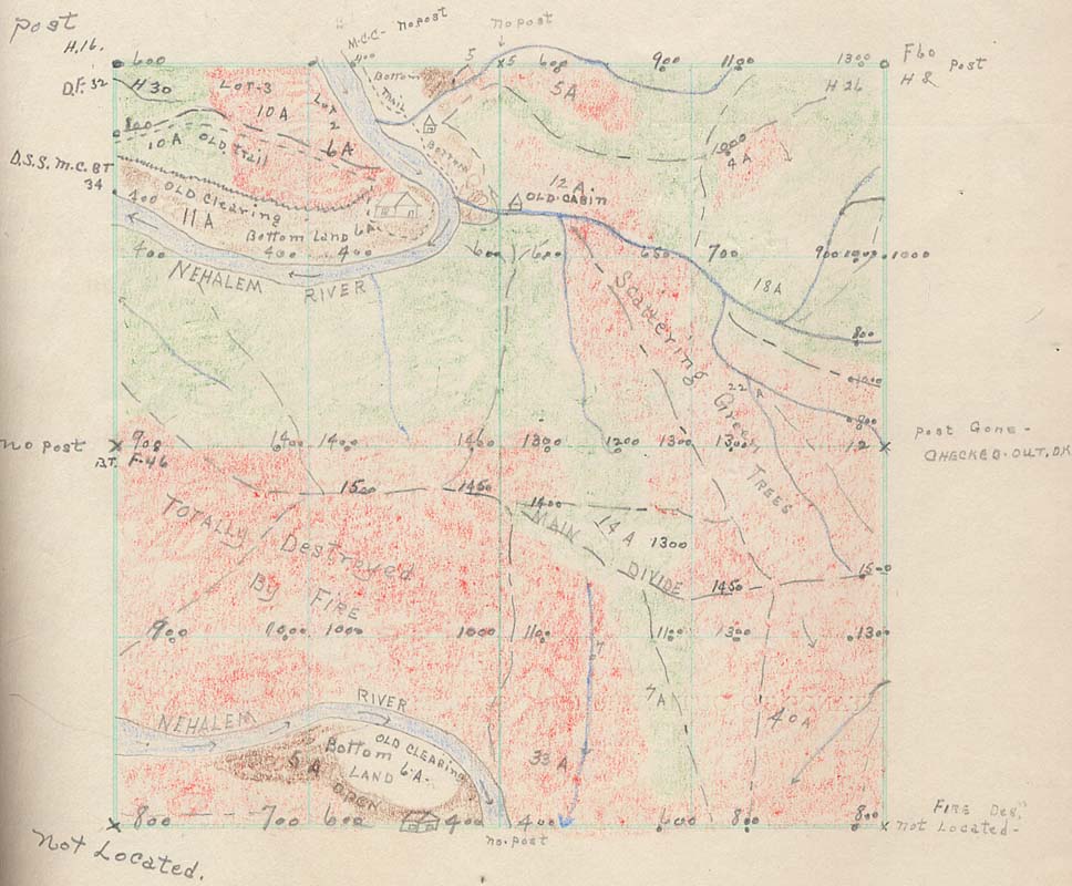
Map 4.02 Tsp. 4 N., Rng. 8 W., Sec. 35 timber cruise map, 1913.
Map 4.03 compares a hand-drawn index to the 1913 Tsp. 4 N. timber cruise (Cabe[?] et al. 1913) with 1850, 1890, 1920, and 1940 excerpts from the "Teensma" map series (see Appendix E), and the 1900 (Gannett 1902), 1914 (Elliott 1914), and 1936 (Andrews and Cowlin 1936) GIS patterns described in Chapter 2. The Teensma maps correlate poorly, if at all, to the historical maps and are not further considered in this analysis. The scattering of fires shown on the eastern portion of Tsp. 4 N. corresponds to similar patterns in the 1913 cruise, as do the large fire patterns on the western portion of the 1914 map. The 1936 patterns show both similar patterns of fire, and subsequent logging patterns (black polygons) that conform to the unburned portions of the 1913 cruise.
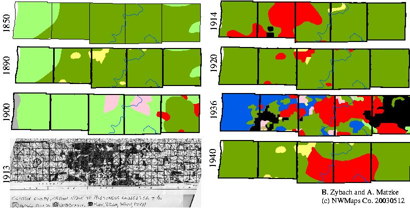
Map 4.03 Clatsop County Tsp. 4 N. fire patterns, 1868-1936.
Map 4.04 was constructed by comparing (see Map 4.03) and layering GIS forest and fire history data derived from GLO surveys (Christy and Alverson 2003), Gannet (1902), Elliott (1914), Andrews and Cowlin (1936), and the patterns developed for Map 3.02. The 1720-1780 pattern was derived from a 1936 Douglas-fir size classification that also dominated the Millicoma Fire pattern at that time. There is no further evidence of forest fires from that time period. Two significant patterns emerge: 1) a large amount of forestland was left unburned during the past 250 years, and 2) there is a strong and obvious correlation between Indian burning patterns and subsequent wildfire locations (including ignition points) and wildfire boundaries.
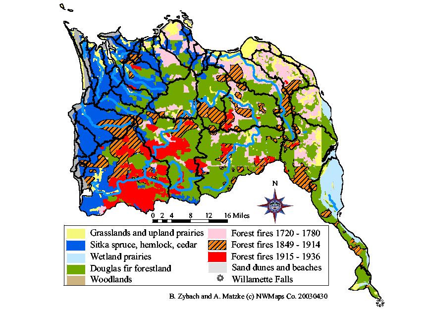
Map 4.04 Northern Oregon Coast Range forest fire patterns, 1720-1936.
Several likely reasons exist for the relative absence of forest fires in this subregion: three of the four boundaries are large expanses of water--the Pacific Ocean, the Columbia River, and the mainstem Willamette River from the Falls to its mouth, making fire entries from the east and north difficult and unlikely; the climate is generally foggier with more rainfall than other parts of the Coast Range (see Map 1.04); the greater precontact population was comprised of Chinookan people, who tended to spend much of their time close to riverine environments, rather than managing upland areas; a large portion of native vegetation is spruce and hemlock forest, which tends to burn less frequently than Douglas-fir forest (Agee 1993); the topography is heavily dissected compared to the other subregions of the Range, thereby making fire more difficult to carry (see Map 1.02); and much of the area was logged (see Fig. 4.02) before it could burn.
There are several striking correlations between precontact Indian burning patterns and subsequent catastrophic fire patterns: 1) the majority of tideland, wetland and grassland prairies follow canoe and foot trails adjacent to the Columbia, Youngs, Clatskanie, and Nehalem rivers; 2) ignition points of most wildfires correlate closely with well-established riparian and ridgeline travel corridors and destination points; 3) the boundaries of most wildfires correlate to precontact prairies, foot trails, and canoe routes; and 4) fogbelt spruce and hemlock forests show relatively minor evidence of either precontact Indian burning or subsequent forest fires.
An additional pattern of land use activities represented by these maps is also of interest. The 1936 pattern of logging (black polygons) correlates closely to unburned areas represented on the 1900, 1913, and 1914 patterns. Map 4.05 and Map 4.06 provide additional evidence of this relationship. These maps showing logging and reforestation patterns for most of the Oregon Coast Range from ca. 1900-1935 (Lindgren 1935). The pattern of Tsp. 4 N. logging on Map 4.05 can be compared with fire and logging patterns shown on Map 4.03 to provide additional corroboration. Also note the close conformance between historical burn patterns of 1913-1914 with small diameter (less than 20 inches d.b.h.) conifer stands of 1935, adding additional credence to the assumed 1720-1780 fire pattern assumptions.
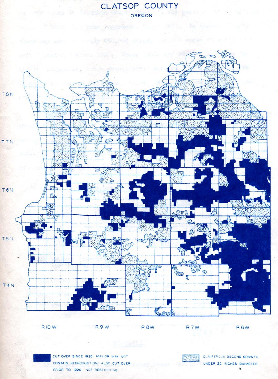
Map 4.05 Clatsop County logging patterns, ca. 1900-1935
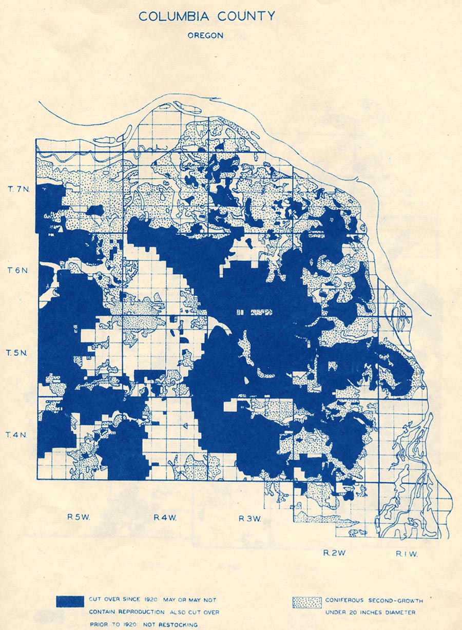
Map 4.06 Columbia County logging patterns, ca. 1900-1935.
According to their source (Lindgren 1935: 8), these two maps represent 40,060 acres of pre-1921 logging and deforested burns for Clatsop County and 56,865 acres of the same classification for Columbia County (96,925 total acres), and 105,295 acres of 1921-1935 logging for Clatsop County and 117, 180 acres of the same classification for Columbia County (222,475 total acres). Total logging acreage for the northern Coast Range, therefore, is comparable to catastrophic fire event acreages in other areas of the region.
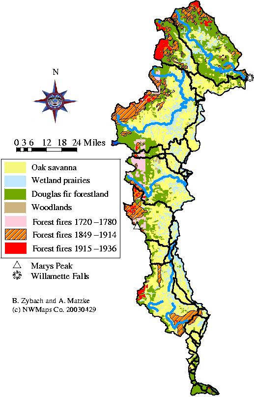
Cultural legacy is defined as the evidence of trails, savannah, prairies, fields, berry patches, brakes, balds and other environmental indications of human land uses that persist through time. This process is illustrated, among other places throughout this thesis, by the map and photographs in Appendix H. For the eastern Coast Range, the role of precontact burning practices in relation to subsequent wildfire history is obvious: precontact Kalapuyan people maintained an environment that was largely free of contiguous forestland, thereby making forest fires, by definition, impossible. Subsequent white settlers, for the most part, maintained the forest-free environment through practices of grazing, plowing, mowing, logging, planting, and urbanization. Habek (1961: 76) observed: "By the early 1900s it had been noted that no pure pre-settlement tracts of native Willamette Valley vegetation remained". This condition, however, did not affect the basic patterns of vegetation, only the types of species present in grassland, wetland, woodland, and forestland environments. The result has been an extensively managed subregion in which catastrophic forest fires have not taken place simply because there has not been sufficient forested area to house such an event.
Soap Creek Valley (see Map 2.01) is representative of much of the eastern Coast Range in which forest expansion has occurred during historical time (see Fig. 3.05). Scattered old-growth trees dating to 1647 (Starker 1939: 48) existed throughout the grasslands and, contrary to other parts of the Range, were not consumed during regular broadcast burning events. In fact, the opposite effect occurred, similar to the oak and limby Douglas-fir old-growth shown in Fig. 4.01--the frequent fires eliminated most hazardous fuels from the environment, and kept competing vegetation from becoming established, thereby likely protecting these trees' existences through time and allowing them to become much older than they might in a more competitive forest environment. In other words, without sufficient ladder fuels, coarse woody debris build-up, and the development of a contiguous forest canopy, the likelihood of a stand replacement wildfire event is almost nonexistent. Map 4.07 illustrates the process of Soap Creek Valley afforestation shown in Fig. 3.05 (Zybach 1999: 176-210).
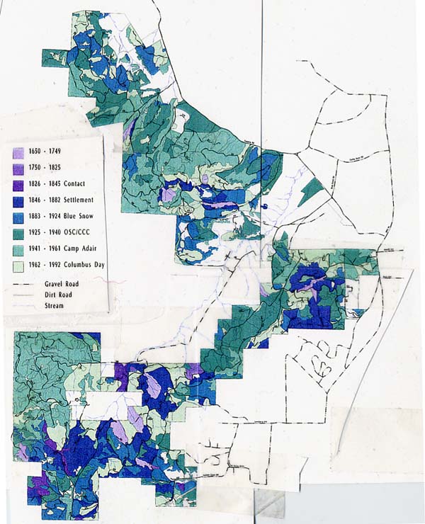
Map 4.07 Soap Creek Valley cultural forest age classes, 1650-1992.
As shown on this map, small pockets of older trees--barely considered old-growth at the time of initial white settlement in 1846--slowly expanded outward from their scattered locations until the early 1800s. Then a series of events occurred over time to cause a large portion of the area to become transformed from oak savannah to conifer forest during the subsequent century: disease decimated local Kalapuyan populations to just a few scattered bands by the 1830s (ibid.: 190-192), probably reducing the amount of annual burning, tillage, and harvesting in the area, and allowing more tree seedlings to become established; white settlers began subdividing and fencing the land in the 1840s (ibid.: 192-198), reducing disturbance in more isolated areas of the valley and further encouraging forest expansion; killing snows and the introduction of automobiles from the 1860s through the 1930s (ibid.: 197-200) sporadically reduced the use of grasslands by grazing animals, thereby allowing for additional forest expansion; the removal of all farmers and grazing animals over much of the area during W.W. II (ibid.: 200-202) completed the process of eliminating grazing animals that trampled and crushed new seedlings, and farmers that seasonally plowed and mowed the remaining fields and meadows. Relatively small wildfires and logging operations helped to curtail the process of prairie afforestation until the 1930s, when the nearby establishment of the Oregon Forest Nursery (ibid: 107-117) coupled with an increase in value of Douglas-fir timber resulted in the planting of forest seedlings throughout much of the remaining unforested and deforested area. Transfer of most of the lands to Oregon State College (OSU) in the early 1950s (ibid.: 126-135) for purposes of agricultural and forestry research and education completed the process: what had been mostly oak savannah in 1850 had become mostly Douglas-fir forest by 1950.
Although the afforestation of Soap Creek Valley was typical of much of the eastern Coast Range, it only represented a fraction of the total area. Much of the remainder continues to remain in a grassland condition to this time, in the forms of lawns, athletic fields, and large, industrial grass seed farms. Most of the land is owned privately, and areas that have been purposefully converted to trees are regularly harvested as pruned saplings for Christmas trees, or as second-growth logs for chipping or milling. Map 4.08, constructed in the same manner as Map 4.04, shows a primary difference between the two areas: neither subregion has been the location (except marginally) of a catastrophic fire during historical time; North, possibly because it was logged before such an event could take place; East, because it has never developed a forest of sufficient size for such an event to occur. In sum, the "cultural legacy" of Kalapuyan land management patterns are still readily apparent throughout the eastern Coast Range, although a significant shift in the variety of plant species has taken place. The lack of catastrophic fire history throughout the subregion seems entirely due to the presence and maintenance of a largely forest-free environment from precontact time to the present.
Map 4.08 Eastern Oregon Coast Range forest fire patterns, 1720-1936.
The Douglas-fir forests of the western Coast Range have
nearly all burned at least once at one time or another during catastrophic
fire events in historical time. Whereas precontact northern Coast Range
forests have been mostly logged, and eastern Coast Range lands have
been mostly grazed, mowed, or otherwise cultivated, the precontact
forests of this subregion have mostly burned. The Yaquina, Nestucca,
and Tillamook fires (see Map 4.01) all took place in the western Coast
Range, extending into the southern reaches of the Nehalem River to
the north, likely being ignited along the shared ridgeline brakes and
forests boundary of the Willamette Valley to the east, and extending
southerly to its shared wildfire history of the Siuslaw and Umpqua
valleys to the south. The western boundary of these fires is generally
the fogbelt spruce-hemlock forests that skirt the Pacific Ocean, but
sometimes is the actual ocean beaches themselves (see Appendix C).
Map 4.09 shows the extensive
nature of western Coast Range catastrophic forest fires. It was
constructed in the same manner as
Map 4.04 and layered with the
precontact burning patterns shown on Map 3.06. As with the northern
Coast Range, there are several striking correlations
between precontact Indian burning
patterns and subsequent catastrophic fire patterns: 1) the majority
of tideland, wetland and grassland prairies follow
north-south canoe and foot
trails adjacent to the ocean beaches and west-east canoe and foot
trails that entered the interior of the subregion via the
major river drainages; 2) ignition
points of most wildfires correlate closely with well-established
riparian and ridgeline travel corridors and destination
points; and 3) the boundaries
of most wildfires correlate to precontact prairies, ridgeline
foot trails, and canoe routes.
Map 4.09 Western Oregon Coast Range forest fire patterns, 1720-1936.
Because the western Coast Range contains the greater share of catastrophic fire history for the region, I have included the following series of maps to better consider the potential relationships between precontact burning patterns and subsequent wildfires. Map 4.10 is excerpted from a 1929 timber cruise of Lincoln County (Pearson, Grady & Co. 1929) and annotated to illustrate the southern extent of the Nestucca Fire from the north, the northeast corner of the Yaquina Fire to the south, and the 1910 South Fork fire to the east. The 1966 Stott Mountain is also shown. The fire and logging history of the Siletz basin is similar to that of the northern Coast Range. A large block of old-growth Sitka spruce to the west was logged along the Siletz River mainstem between 1920 and 1940; the "Siletz Gorge" to the east contained about 100,000 acres of old-growth Douglas-fir that was primarily logged during a 20-year period following W.W. II. The pattern of precontact burning is reflected in local landscape names such as Camas Prairie, Peavine Ridge, and Siletz Prairie (see Appendix B). These patterns were used as a basis for assembling Map 4.09, which clearly shows the large blocks of spruce and Douglas-fir that were left unburned, and later logged. As can be seen, the Siletz basin was one of the few areas of the western Coast Range that contained a significant amount of forestland to escape wildfire during the past 250 years.
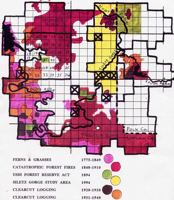
Map 4.10 Siletz River basin forest fire patterns, 1849-1966.
Map 4.11 is based on the "Alseya Valley" boundaries shown on Map 2.13. The same boundaries are used to compare the 1900 (Gannett 1902), 1914 (Elliott 1914), and 1936 (Andrews and Cowlin 1936) GIS patterns described in Chapter 2. In this instance, the 1900 pattern is shown to be too general to further consider, but the 1914 and 1936 patterns are complementary to earlier GLO surveys (see Appendix D) and sufficiently accurate to layer into a regional scale map (Map 4.09), as previously determined by the earlier analysis of Map 2.15.
Map 4.11 Alsea Valley forest fire patterns, 1900-1936.
Map 4.12 shows the "Alseya Valley" precontact ridgeline foot-trail and riparian canoe trail network (see Fig. 2.05) within context of the greater Alsea River basin. The network was mapped using 1853-1897 GLO survey notes as described in Appendix D and extended over the entire basin by use of a CLAMS 5th-field watershed GIS layer (see Table 2.03). As can be seen, there is a nearly seamless connection between the surveyed trails and the proxy measures along nearly the entire 50-mile perimeter of the Alseya Valley study area. The reasons for this conformity can be readily determined by looking at Fig. 2.05 and adds significant confidence to the use of proxies to develop the entire pattern. The Klickitat horse trail of 1849-1853 that extends from Klickitat Lake near Marys Peak to Klickitat Mountain near Yachats River is also connected by this method, adding further confidence to the result.
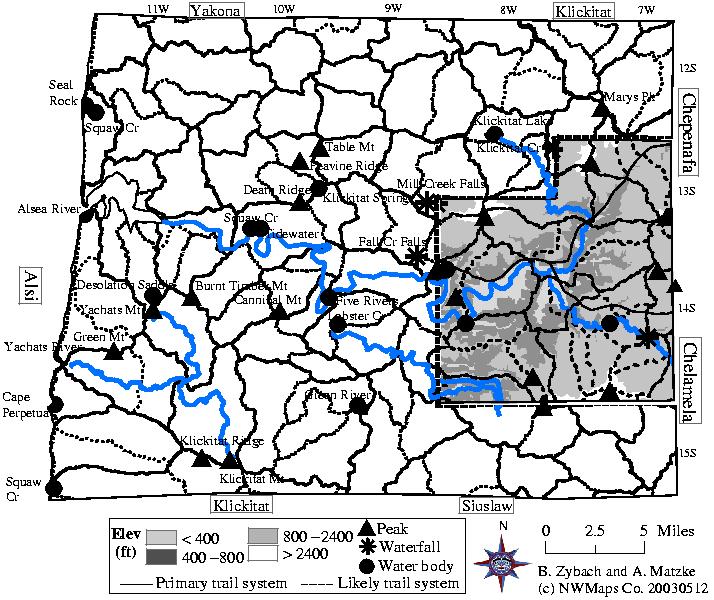
Map 4.12 Alsi tribe foot, horse, and canoe trails, 1826-1853.
Map 4.13 was constructed by layering the precontact trail patterns of Map 2.13 over historical wildfire and precontact vegetation patterns excerpted from Map 4.09. The result, derived from entirely different sources of information, is striking: 1) the detailed pattern of relatively small 1915-1936 fires clearly follow established routes of precontact travel; 2) fire boundaries are determined by a combination of precontact prairies and trails, sometimes to an exacting degree; 3) wildfire boundaries, over time, connect to one another major travel routes. This latter observation can be seen by the nearly due east and west series of fires across the northern portion of the map from Seal Rocks (a well-known precontact townsite and/or campground) to the Willamette Valley and by the diagonal series of fires from southwest to northeast that follows the Klickitat horse trail. These fire patterns are not random and clearly conform to precontact and early historical Indian burning patterns.
Map 4.13 Alsea River basin forest fire patterns, 1849-1936.
Map 4.14 Coos Bay forest fire patterns, 1895-1936.
Map 4.15 Southern Oregon Coast Range forest fire patterns, 1720-1936.
This chapter focuses on two key points: 1) the unknown
factors associated with the
widespread forestation of Oregon Coast Range lands in the 16th and
17th century; and 2) the strong coincidence
between precontact and early
historical patterns of Indian burning that had all but ended by 1848,
and the subsequent patterns of catastrophic
forest fires that continued
until 1951. For the first point, I would like to propose the hypothesis
that large-scale reductions in local
human populations 400 or 500
years ago may have led to immediate and dramatic increases in forestland
acreage (although, certainly, other
factors may well have been
responsible, in whole or in part, for this result). The second point
is the focus of this thesis and is summarized
in accordance with the types
of patterns listed in Chapter 1: 1) sources of ignition; 2) timing
of fires; 3) spatial boundaries of fires; 4)
fire intensities; 5) human
safety; and 6) effects on wildlife habitat.
Was widespread conifer forestation
throughout the Oregon Coast
Range in the 1500s and 1600s possibly triggered by a
significant decline in human populations? If
large numbers of people died on the Coast Range between 1500 and 1550--and some
evidence suggests that may well have happened throughout North America after
1492 (Denevan 1992)--then I think a number of processes would have occurred on
a grand scale that would have been similar to what happened after 1775, 1830,
1850; that is, a widespread afforestation of Indian prairies, brakes, balds and
savannahs tied to the cessation or large-scale reduction of Indian burning practices
(see Appendix F). The number and size of towns would be reduced. Survivors would
likely be in shock and less inclined to venture into isolated areas away from
towns and established campgrounds. Hunting and gathering would be greatly reduced
and deer, elk, bear, seal, sea lion, clam, and mussels populations would likely
boom (Kay 2002: 248-250). Many heavily tilled swamps and marshes, with a reduction
or elimination of regular harvesting activities, would begin to grow trees (willow,
ash, crabapple, cedar, cottonwood, etc.), as would scattered meadows, abandoned
townsites, inland prairies, and the perimeters of savannahs. If oaks and/or filberts
were being managed as plantations (speculative evidence), the creation of new
orchards would stop. Spruce and hemlock would begin foresting coastal headlands,
ridges, prairies, and valleys, as Vaughn described for the Tillamook area in
the 1850s (Vaughn 1928); Douglas-fir would begin populating isolated meadows,
prairies, berry patches, and the perimeters of bottomland prairies and savannah,
as Moravets (1932) describes; true fir would begin populating higher elevation
berry patches and the perimeters of balds on the west slope, and seeps and highlands
within the Willamette Valley; and riparian areas would begin to grow brush and
gallery forests in many places (see Fig. 3.05). The whole process would take
about 20-60 years (e.g., Gannett 1902; Weyerhaeuser 1947; Winter 2002), and by
1600-1650, a large portion of the Coast Range would be coated with young and
thriving second growth stands containing hardly any snags or "coarse woody
debris" (CWD), and interspersed with scattered pockets and relatively small
stands of parent seed trees. By 1800, many of these stands would be old-growth
around 200 years of age, and by 1950 they would be 350 year-old trees very similar
to "ancient" forestlands described in FEMAT (1992), but with a marked
absence of charred snags, stumps, logs or other "biological legacy",
as generally speculated at this time (e.g., Impara 1998). (However, if current
assumptions were true--that historical stands rose from the ashes of widespread
catastrophic fires--there should have been a huge influx of carbon in lakes,
swamps, and soil horizons that we should be able to locate and date). Large-scale "one
careless match" fires, independent of changed human population numbers would
begin to enter the landscape as canopies filled in and tree mortality created
fuels (about 1700 and thereafter), so a large-scale mosaic of even-aged tracts
would begin to form. Reburns would begin to reduce the amount of snags, CWD,
and biological legacy in those areas as well, but there would still be more of
these materials than in the parent stands, due to increased tree densities that
preceded mortality.
In sum, if large scale reductions of human populations
in the early 1500s had taken place in the 1500s, and if this event
had resulted in the afforestation
of previously managed lands as took place in historical time, then the final
result may have been very much like the forests described and documented in early
historical time. Other possibilities include widespread catastrophic fires with
repeated reburns that removed most evidence of biological legacy (but should
have resulted in identifiable and datable prisms of carbon throughout the region);
a series of widespread disturbances that included wind, fire, insects, disease,
and/or landslides followed by a similar series of fires and reburns; or a combination
of reduced Indian burning, catastrophic fires, and other disturbances which varied
from location to location. Any of these four results (cessation of Indian burning,
regional wildfires, multiple events, or a combination of the three) would have
had to have taken place within 100-150 years and then all but stopped from 1600
or 1650-1848 to have resulted in historical conditions.
2) Indian burning and catastrophic fire pattern comparisons
The strong coincidence between precontact and early
historical patterns of Indian
burning and the subsequent "Great Fires" includes considerations of
sources (and locations) of ignition, timing of fires, spatial boundaries of fires,
fire intensities, human safety, and effects on wildlife habitat. Other patterns
are associated with climate, topography, and land ownership. Catastrophic fires
on the Coast Range seem to share the following characteristics: a) started by
people, b) occur on the western slope of the range, c) occur in August and September,
d) move on east winds in a south-westerly fashion, e) cover more than 100,000
acres of forestland, and f) extinguished with fall rains.
Sources of ignition. Indian burning patterns, by definition,
are caused by people. Occasional fire escapements were probably a significant
part of the landscape
pattern created by regular fire use. All evidence associated with catastrophic
fire causes and most evidence associated with ignition sources during catastrophic
fire years show people, rather than lightning or any other source, as principal
causes of these events, too. Known ignition points of wildfires correlate closely
with well-established precontact riparian and ridgeline travel corridors and
destination points. Fires occurring after 1848, whether controlled or wild, can
likewise be attributed almost entirely to whites, often for differing land management
purposes than their Indian predecessors.
Timing of fires. Historical accounts of broadcast burning
activities in the Coast Range occur during two fire seasons: late winter/early
spring "fern burning",
and late summer/early fall "field burning". All catastrophic fires
are associated with the late summer/early fall "fire season", especially
during the months of August and September.
Spatial boundaries. The majority of tideland, wetland
and grassland prairies follow north-south canoe and foot trails adjacent
to the ocean beaches and the
Willamette River, and connective west-east canoe and foot trails that entered
the interior of the subregion via major river drainages and ridgeline alignments.
The boundaries of most wildfires correlate closely to this pattern of precontact
prairies, ridgeline foot trails, and canoe routes.
Fire intensities. Indian burning patterns were based
on regular and seasonal fires that consumed fuels incrementally, or
covered areas with such frequency
that fires seldom occurred in areas of heavy forest or fuels. Catastrophic fires,
on the other hand, typically followed centuries of tree growth or burned through
areas of standing snags and downed logs remaining from earlier wildfires. Differences
in fire intensity can be easily inferred from figures representing the localized
cooking fires or seasonal "cool burns" of Indians in Chapter 3, and
those illustrating the killed timber and mushroom clouds representing the later
events in this chapter. The coincidence in these patterns is temporal: the earlier
controlled burns consumed a minimum of fuel as they "flashed" through
a landscape of ferns, grasses, and shrubs, while the later wildfires burned as
hot and explosively through massive conifer forests as any on record.
Human safety. There are only a few cases of human deaths
known to be related to Oregon Coast Range forest fires (e.g., see Appendix
C), and none known to
be associated with precontact Indian burning practices.
Wildlife populations. There are no long-term reductions
in local wildlife populations that have been associated with either
Indian burning or catastrophic forest fires.
Deer, elk, berry, grass, oak, and bear populations would likely decline through
time as forests expanded their range (Kay 2002), and increase in numbers as they
burned or were otherwise cleared. The development and maintenance of transportation
corridors, extensive oak savannahs, prairies, berry patches, filbert groves,
camas fields, lawns, and balds by Indian burning practices (Table 3.03) also
resulted in beneficial habitat to a number of plant (Table 3.05) and animal (Table
3.06) species. During wildfire events, these areas could also function as "refuges" for
threatened wildlife species.
Climate. Graumlich (1987) analyzed tree rings to arrive
at a 300-year precipitation pattern that identified specific years
(1717, 1721, 1739, 1839, 1899, 1929, and
1973) and at least one decade per century (1790s, 1840s, 1860s, 1920s, and 1930s)
of prolonged regional drought. The annual drought events seem to have no significant
relationship to Coast Range fire history, but the prolonged droughts correlate
closely with major forest fire events identified in this chapter. All of these
fires, however, are known or believed to have occurred during the late summer-early
fall months of August and September. Thus, there is a strong correlation between
fire events and seasonal weather patterns, but people, rather than lightning
or other weather-related causes, are responsible for the large majority of fires
in the Coast Range (see Table 4.02)
Topography. Topography plays an important part in affecting
burn patterns of Coast Range forest fires. In heavily dissected areas,
such as the headwaters
of the Nehalem or Siletz rivers, large areas of forest typically avoid being
burned (see map 4.01). In "rolling" areas of topography, such as the
Yaquina and western Coos river drainages, almost all trees over large expanses
of land might be killed. "Flat" areas of the Range, such as the Willamette
and Umpqua river valley floodplains, have typically been used by people for thousands
of years and thus have not been subjected to forest fire at all.
Landownership patterns. Oregon
Coast Range land ownerships also play a significant role in landscape
patterns of purposeful burning and large scale wildfires. Precontact
burning practices varied significantly between Chinookan,
Kalapuyan, Athapaskan,
and Yakonan tribes, for example (see Map 3.01 and Chapter
3.D), and resulting landscape patterns reflect those differences.
Current forest landownership patterns,
on the other hand, correlate closely to historical catastrophic
fire patterns (see Map 4.01 and Map 6.01): the Millicoma fire
developed a dense, even-aged
stand of second-growth Douglas-fir that was owned and
mostly logged by Weyerhaeuser Timber Co. (see Fig. 4.03) during
the latter half of the 20th century; the Yaquina
and Nestucca fire boundaries of the mid-1800s (see Fig.
4.05) are similar to the current boundaries of the Siuslaw National
Forest; the 1868 Coos Fire (see
Fig. 4.06) closely matches the current boundaries of
the Elliot State Forest; and the Tillamook fires of the first
half of the 20th century (see Fig. 4.07,
Fig. 4.08, and Map 4.09) evolved into today's Tillamook
State Forest.